FAA Certifies G500H For MD 500 Series Aircraft | Aero-News Network
Aero-News Network
RSS icon RSS feed
podcast icon MP3 podcast
Subscribe Aero-News e-mail Newsletter Subscribe

Airborne Unlimited -- Most Recent Daily Episodes

Episode Date

Airborne-Monday

Airborne-Tuesday

Airborne-Wednesday Airborne-Thursday

Airborne-Friday

Airborne On YouTube

Airborne-Unlimited-05.13.24

Airborne-NextGen-05.14.24

Airborne-Unlimited-05.15.24 Airborne-AffordableFlyers-05.16.24

Airborne-Unlimited-05.17.24

Tue, Mar 06, 2012

FAA Certifies G500H For MD 500 Series Aircraft

Installation Is Available As OEM, Retrofit

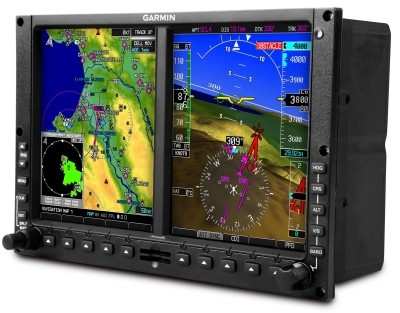
MD Helicopters has received FAA certification of the Garmin G500H electronic flat panel displays. The G500H system, approved under the Type Certificate of the MD 500, is available for production and  retrofit installation in the MD 500E, MD 530F and MD 520N helicopters. Installation is immediately available for production aircraft, and for retrofit installations performed at the MD Factory Service Center in Mesa, Arizona. Kits will soon be available for installation at either MD Authorized Service Centers or at Garmin Authorized Dealer Network facilities.

“Upgrading the flight display systems and the single engine cockpit was a priority for the Company, said Lynn Tilton, CEO of MD Helicopters. This offering allows our single-engine customer base to enhance their favored airframe with the revolutionary pilot-centered avionics tools Garmin offers.”

The Primary Flight Display (PFD) and Multi Function Display (MFD) provide easy visual scanning and interpretation. Garmin’s G500H dual-screen electronic flight display offers an affordable flight solution that meets the needs of the most demanding helicopter missions. The PFD screen shows attitude, airspeed, altitude, climb rate and course/heading information — while the MFD screen provides detailed moving-map graphics depicting the helicopter’s current position in relation to ground features, chart data, navaids and flight plan routings. Optional Synthetic Vision Technology (SVT) provides unparalleled situational awareness crucial to helicopter operations. To help monitor location on unfamiliar airports, the G500H comes with preloaded geo-referenced SafeTaxi diagrams for over 900 U.S. airports. A simple-to-navigate interface is accessed by a rotary knob for data entry and soft-keys for mode selection. A front-loading SD card slot makes it easy to add data and make updates. (Image provided by Garmin)

FMI: www.mdhelicopters.com

Advertisement

More News

ANN's Daily Aero-Term (05.17.24): Very High Frequency

Very High Frequency The frequency band between 30 and 300 MHz. Portions of this band, 108 to 118 MHz, are used for certain NAVAIDs; 118 to 136 MHz are used for civil air/ground voi>[...]

ANN's Daily Aero-Linx (05.17.24)

Aero Linx: Aviation Suppliers Association Established February 25, 1993, the Aviation Suppliers Association (ASA), based in Washington, D.C., is a not-for-profit association, repre>[...]

ANN FAQ: Submit a News Story!

Have A Story That NEEDS To Be Featured On Aero-News? Here’s How To Submit A Story To Our Team Some of the greatest new stories ANN has ever covered have been submitted by our>[...]

Classic Aero-TV: ANN Visits Wings Over The Rockies Exploration Of Flight

From 2021 (YouTube Version): Colorado Campus Offers aVariety Of Aerospace Entertainment And Education Wings over the Rockies Exploration of Flight is the second location for the Wi>[...]

Airborne Affordable Flyers 05.16.24: PRA Runway, Wag-Aero Sold, Young Eagles

Also: Paramotor Champ's, Electric Ultralight, ICON BK Update, Burt Rutan at Oshkosh! The Popular Rotorcraft Association is reaching out for help in rebuilding their private runway >[...]

blog comments powered by Disqus


Advertisement

Advertisement

Podcasts

Advertisement

© 2007 - 2024 Web Development & Design by Pauli Systems, LC