Dart, Flight Management Systems, Partner To Provide Digital Maps | Aero-News Network
Aero-News Network
RSS icon RSS feed
podcast icon MP3 podcast
Subscribe Aero-News e-mail Newsletter Subscribe

Airborne Unlimited -- Most Recent Daily Episodes

Episode Date

Airborne-Monday

Airborne-Tuesday

Airborne-Wednesday Airborne-Thursday

Airborne-Friday

Airborne On YouTube

Airborne-Unlimited-06.10.24

Airborne-NextGen-06.11.24

Airborne-Unlimited-06.12.24 Airborne-FltTraining-06.13.24

Airborne-Unlimited-06.14.24

Sat, Jan 09, 2010

Dart, Flight Management Systems, Partner To Provide Digital Maps

System Based On GIS Technology

Dart Helicopter Services (DHS) has announced a new distribution agreement with the Flight Management Systems (FMS). The relationship will allow DHS customers access to another useful helicopter accessory: digital moving maps.

“FMS is a leader in digital moving map technology,” said Jeff Shapiro, DHS President. “The relationship is a valuable addition for us. We are excited to be able to work with FMS to offer their map system to our customers.”

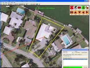
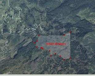
The moving map software utilizes geographic information systems (GIS) to offer more information than conventional scanned paper maps. In addition to being current, the technology enables a user to add as many layers of information as needed. Being able to view the location of potential hazards like cell phone towers and electrical wires, as well as helpful information like underground pipelines, and reverse 911 information, the map can enable the team to quickly and accurately identify a target address. Also, data gathered during a mission can be transferred to another system via USB, making information sharing simple.

“The entire FMS team is excited about the opportunities our relationship with DHS will bring.” FMS president Greg Taylor added “Although we have a presence in several global locations, we will be able to reach those in Europe, an area we haven’t serviced yet.”

FMS leadership has over 32 years of helicopter maintenance, police and aerial fire fighting experience and the company has been flying with the moving map technology since 1996, giving them the experience they need to make recommendations appropriate for any situation.

FMI: www.flightmanagementsystems.com, www.darths.com/

Advertisement

More News

USCG MH-60 To The Rescue (Again) -- Rescues 4 Boaters

Capsized Vessel Located Near Dauphin Island, Alabama The Coast Guard rescued four boaters after their vessel capsized near Dauphin Island, Alabama, Thursday. Coast Guard District E>[...]

Gray Eagle Order Placed for Army National Guard

Reserve Components Looking to Improve In-House General Atomics Aeronautical Systems announced a fresh order for a dozen Gray Eagle 25M UAVs with accompanying equipment, for fulfill>[...]

Aero-Biz Survival 101 (1120a): Expert Ideas To Help You Through Tough Times

Brand New! Avoid The Need For A Comeback... Get Your Marketing Right, Right Now! Some time ago, the Aero-News Network, responding to numerous requests, established a marketing and >[...]

Airborne 06.03.24: Rotax 915/916 SB, Starship 4 Ready?, B-17 Mementos

Also: Hubble On Pause, FedEx Pilots Picket, Nexus eVTOL, VFS Honors The Rotax folks have published a Service Bulletin after issues were noted that may affect all R915i and R916i se>[...]

Mid-Continent Instruments and Avionics Mourns Former Leader

John W. Winter of AEA and Avionic Fame Passes John W. Winter brought Mid-Continent Instrument Company into the modern era in 1980, purchasing the firm and using it as a base for ex>[...]

blog comments powered by Disqus


Advertisement

Advertisement

Podcasts

Advertisement

© 2007 - 2024 Web Development & Design by Pauli Systems, LC