ESA Provides 3-D Glimpse Of Red Planet | Aero-News Network
Aero-News Network
RSS icon RSS feed
podcast icon MP3 podcast
Subscribe Aero-News e-mail Newsletter Subscribe

Airborne Unlimited -- Most Recent Daily Episodes

Episode Date

Airborne-Monday

Airborne-Tuesday

Airborne-Wednesday Airborne-Thursday

Airborne-Friday

Airborne On YouTube

Airborne-Unlimited-04.29.24

Airborne-NextGen-04.30.24

Airborne-Unlimited-05.01.24 Airborne-AffordableFlyers--05.02.24

Airborne-Unlimited-05.03.24

Fri, Feb 08, 2008

ESA Provides 3-D Glimpse Of Red Planet

High-Res Camera Image Released Online

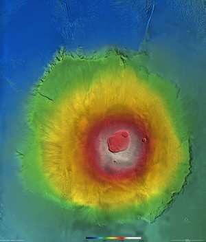
Mars is about to come into focus as never before, thanks to the data from the Mars Express High Resolution Stereo Camera (HRSC). A new high-resolution Digital Terrain Model data set, released this week onto the Internet, will allow researchers to obtain new information about the Red Planet... in 3-D, no less.

Digital Terrain Models (DTMs) allow scientists to 'stand' on planetary surfaces. Although ordinary images can give spectacular bird's-eye views, they can only convey part of the picture. They miss out on the topography, or the vertical elevation of the surroundings.

That's where the Mars Express comes in. The HRSC was especially designed to provide this information and, after years of specialised data processing, the first comprehensive release of 3D data of a large part of the martian surface is now ready.

"Understanding the topography of Mars is essential to understanding its geology," says Prof. Gerhard Neukum, Freie Universitat (FU) Berlin, Germany, Principal Investigator for the HRSC.

The DTM can instantly tell researchers the slope of hillsides or the height of cliffs, the altitude and slope of lava flows or desert plains. "This data is essential for understanding how water or lava flowed across Mars," says Neukum.

It also helps planetary scientists to better interpret other data sets, for example the results of the Mars Advanced Radar for Subsurface and Ionosphere Sounding (MARSIS). "Once we know where the surface is, we can correctly interpret the radar echoes we get from below it," says former ESA scientist Angelo Rossi, a member of the HRSC team.

The Mars Express DTM is the most detailed topographic data set ever released for Mars. Its release has been made possible by processing individual image swaths taken by the HRSC as Mars Express sweeps through its orbit. The individual swaths are then put together into mosaics that cover large regions. The high-resolution images used have a resolution of 10 m/pixel. The DTM elevation data derived from these images is provided in pixels of up to 50 m, with a height accuracy of 10 m.

The orbit of Mars Express determines the resolution of its pictures. When it is closest to the surface, it can take the most detailed pictures. "As the mission continues, we are gradually filling in the gaps and collecting high-resolution data whenever possible," says Neukum.

The team plans to add more data to the DTMs to extend the surface coverage as Mars Express continues its mission until at least 2009 and HRSC continues its unique scrutiny of the planet.

FMI: www.esa.int

Advertisement

More News

ANN's Daily Aero-Linx (05.02.24)

Aero Linx: Model Aeronautical Association of Australia MAAA clubs are about fun flying, camaraderie and community. For over 75 years, the MAAA has been Australia’s largest fl>[...]

ANN's Daily Aero-Term (05.02.24): Touchdown Zone Lighting

Touchdown Zone Lighting Two rows of transverse light bars located symmetrically about the runway centerline normally at 100 foot intervals. The basic system extends 3,000 feet alon>[...]

Aero-News: Quote of the Day (05.02.24)

“Discovery and innovation are central to our mission at Virgin Galactic. We’re excited to build on our successful record of facilitating scientific experiments in subor>[...]

ANN FAQ: Contributing To Aero-TV

How To Get A Story On Aero-TV News/Feature Programming How do I submit a story idea or lead to Aero-TV? If you would like to submit a story idea or lead, please contact Jim Campbel>[...]

NTSB Final Report: Cirrus Design Corp SR20

Student Pilot Reported That During Rotation, “All Of A Sudden The Back Of The Plane Kicked To The Right..." Analysis: The student pilot reported that during rotation, “>[...]

blog comments powered by Disqus


Advertisement

Advertisement

Podcasts

Advertisement

© 2007 - 2024 Web Development & Design by Pauli Systems, LC