Bye Engineering, GNSS Announce Project Milestone | Aero-News Network
Aero-News Network
RSS icon RSS feed
podcast icon MP3 podcast
Subscribe Aero-News e-mail Newsletter Subscribe

Airborne Unlimited -- Most Recent Daily Episodes

Episode Date

Airborne-Monday

Airborne-Tuesday

Airborne-Wednesday Airborne-Thursday

Airborne-Friday

Airborne On YouTube

Airborne-Unlimited-04.29.24

Airborne-NextGen-04.30.24

Airborne-Unlimited-05.01.24 Airborne-AffordableFlyers--05.02.24

Airborne-Unlimited-05.03.24

Mon, Sep 26, 2011

Bye Engineering, GNSS Announce Project Milestone

Solar Electric Airship UAV Development Advances

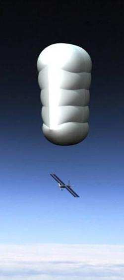
Global Near Space Services (GNSS) and Bye Engineering Partners say they've concluded Phase 2 engineering of the StarLight high-altitude long-endurance solar electric airship intelligence and surveillance platform (pictured). The program was conducted under the supervision of the Naval Air Systems Command, Aircraft Division.

Ron Oholendt, GNSS president, explains, “Preliminary design of the unique airship upper stage and detail engineering and subscale prototyping of the flying solar electric lower stage has been completed." 

The NAVAIR program manager for this effort, Steve Huett, says, "GNSS has made great strides in advancing lighter-than-air technology for high altitude flight operations.”

StarLight is designed to help commercial, state and federal customers obtain satellite-like telecommunications and high-altitude surveillance capabilities for a fraction of the cost of space-based systems. StarLight is unique in the combination of a lighter-than-air upper stage, and a recoverable solar electric lower stage flying vehicle. The lower stage vehicle also provides control and propulsion for non-tethered station keeping.

The program expects to transition from detail engineering to prototype in the near term.

FMI: www.globalnearspace.com ; www.ByeEngineering.com

Advertisement

More News

ANN's Daily Aero-Term (05.02.24): Touchdown Zone Lighting

Touchdown Zone Lighting Two rows of transverse light bars located symmetrically about the runway centerline normally at 100 foot intervals. The basic system extends 3,000 feet alon>[...]

Aero-News: Quote of the Day (05.02.24)

“Discovery and innovation are central to our mission at Virgin Galactic. We’re excited to build on our successful record of facilitating scientific experiments in subor>[...]

Aero-News: Quote of the Day (05.03.24)

"We are reaching out to you today on behalf of the Popular Rotorcraft Association because we need your help. We are dangerously close to losing a critical resource that if lost, wi>[...]

ANN's Daily Aero-Term (05.03.24): UAS Traffic Management (UTM)

UAS Traffic Management (UTM) The unmanned aircraft traffic management ecosystem that will allow multiple low altitude BVLOS operations and which is separate from, but complementary>[...]

ANN's Daily Aero-Linx (05.03.24)

Aero Linx: Society of Aviation and Flight Educators (SAFE) SAFE is a member-oriented organization of aviation educators fostering professionalism and excellence in aviation through>[...]

blog comments powered by Disqus


Advertisement

Advertisement

Podcasts

Advertisement

© 2007 - 2024 Web Development & Design by Pauli Systems, LC