Can Detect Changes In Sea State, Ocean Colour, Temperature And Reflectance Caused By Objects In The Water
Marine habitats are under serious threat from pollution. To help monitor, restrict and reduce this damage, organizations around the world are increasingly turning to satellite imagery.
An estimated 41% of our oceans are adversely impacted by human activity on land. A significant portion of the waste we create ends up flowing into the ocean, including eight million metric tons of plastic each year – the same as 57,000 blue whales. Plastic debris is thought to kill more than one million seabirds and 100,000 marine mammals each year. Whether by accident or design, humans are also responsible for adding other garbage, oil and toxic waste to the ocean.
Earth observation satellites, which normally operate between 125 and 620 miles above the Earth, are proving increasingly valuable. They can detect changes in sea state, ocean colour, temperature and reflectance caused by objects in the water. This information helps governments, researchers and environmental organisations detect and monitor areas of pollution and work out how to combat them.
Earth observation satellites are able to capture images of huge areas multiple times a day, ranging from a few hundred square kilometres to more than 50,000. The quality of image data across an area remains consistent.
That data falls into two categories – optical and radar. Optical satellites produce imagery similar to a classic photograph – as the human eye sees the world. As such, they can only produce images under the right light and weather conditions. Radar satellite imagery, however, can produce images day or night in almost any weather.
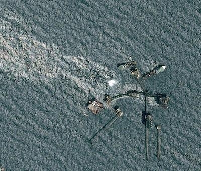
So, what can they see? Airbus’ TerraSAR-X radar satellite can capture images with resolutions of up to 130 feet, making it ideal for detecting objects across large areas and highlighting changes in surface patterns – an oil spill, for example. The company’s Pléiades constellation of optical satellites have a resolution of 20 inches – one pixel for every 1.5 feet – but cover a smaller area. That makes them good at identifying specific boats or objects previously detected by a radar satellite.
The images are used by a variety of organizations, from the European Space Agency (ESA) to coastguard authorities and the United Nations. In the last couple of years, Airbus satellites have helped to detect and monitor oil spills, shipwrecks and toxic gulf weed in the Caribbean.
Airbus is also working on new solutions to the problem. In 2020, it will launch the first satellites in its Pléiades Neo constellation, capable of delivering images with a resolution of one foot. Zephyr, the company’s high-altitude pseudo-satellite, will soon be able to provide additional local image support from its position in the stratosphere, more than 12 miles above the Earth.
Another valuable method of detection is on the water itself. A new smartphone app under development will enable ocean users to report areas of pollution. Satellite imagery will attempt to verify the sightings, before alerting the appropriate authorities.
(Images provided with Airbus news release)
 ANN's Daily Aero-Term (04.25.24): Airport Rotating Beacon

