Altavian Nova UAS Employed To Assist Clients In Mapping Roadways Impacted By Flooding
Michael Baker International has expanded its inspection services with the purchase of an Altavian Nova unmanned aircraft system (UAS). The new fixed-wing Altavian Nova joins the company's expanding UAS fleet, and offers a new tool for Michael Baker pilots to utilize when conducting aerial inspections and mapping of large sites or during inclement weather conditions.
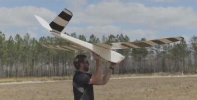
With flight times of 45-90 minutes and the ability to cover 600-800 acres in a single flight, the Altavian Nova, when combined with Michael Baker's extensive fleet of vertical takeoff and landing (VTOL) UAS, and mobile and static Light Detection and Ranging (LiDAR) systems for data collection, expands the company's mapping operations. The extended flight times, coupled with a wide wingspan, increased durability, maritime landing capabilities and ability to handle winds up to 30 miles per hour make the UAS ideal for capturing large projects.
The Altavian Nova is made in the U.S.A. and approved by the Army Corps of Engineers (USACE) for use on USACE or U.S. Army installations. Additionally, the UAS features the most advanced DSLR-based photogrammetric mapping payloads available on the market. The system includes multispectral capabilities, utilizes GPS and IS technologies to transmit data without line of sight, and has remote sensing capabilities and color infrared technology to identify vegetation and natural resources.
"Throughout Michael Baker's history, we have been at the forefront of innovation and technological adoption, incorporating new practices into our existing capabilities to enhance our full continuum of innovative solutions," said Robert Hanson, senior vice president and Technology Practice leader at Michael Baker International. "With the addition of the Altavian Nova to our expanding UAS fleet, Michael Baker continues to serve as an industry leader, capable of offering our clients unmatched aerial mapping and inspection solutions for a range of project types and environments."
Michael Baker is already deploying the new UAS for significant client projects as part of on-call contracts with the Nevada Department of Transportation's Storm Water Division and the Alaska Department of Transportation & Public Facilities. Michael Baker used the Altavian Nova for an emergency task order in response to major flooding of roads and highways along Pyramid Valley, Nev. Low cloud cover and hazardous conditions made the use of ground crews unsafe, so Michael Baker employed the Altavian Nova UAS to capture the entire 15-mile section of damaged highway with precise detail.
"We used our findings from the Nevada DOT project in Nome, Alaska, where a Michael Baker team used the Altavian to map sections of a 34-mile highway that was being washed out yearly by thaw," said Kevin Pomaski, chief UAS pilot at Michael Baker International. "For both clients and projects, Michael Baker relied on the extended range, durability and precision mapping of the Altavian Nova to deliver unmatched solutions for clients."
Michael Baker has a prestigious 77-year history of conducting bridge and infrastructure inspections, including more than 25 years of inspection training for the Federal Highway Administration. The company was also one of the first in the engineering industry to receive certification from the Federal Aviation Administration to operate several types of fixed-wing and vertical take-off and landing UAS, and pioneered the use of UAS for inspections at airports during daily operations.
(Source: Michael Baker International news release. Image from file)
 Sierra Space Repositions Dream Chaser for First Mission

