WingX For Android Version 3 Available Now | Aero-News Network
Aero-News Network
RSS icon RSS feed
podcast icon MP3 podcast
Subscribe Aero-News e-mail Newsletter Subscribe

Airborne Unlimited -- Most Recent Daily Episodes

Episode Date

Airborne-Monday

Airborne-Tuesday

Airborne-Wednesday Airborne-Thursday

Airborne-Friday

Airborne On YouTube

Airborne-Unlimited-05.06.24

Airborne-NextGen-04.30.24

Airborne-Unlimited-05.01.24 Airborne-AffordableFlyers--05.02.24

Airborne-Unlimited-05.03.24

Tue, Jul 23, 2019

WingX For Android Version 3 Available Now

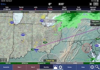
Visual Region Selection, Raster Overlays For Moving Maps Among The Upgrades

WingX has made Version 3 available for Android users. This is a free upgrade for all WingX users, and the company strongly recommends that users upgrade within the next two weeks to ensure uninterrupted service.

The primary features released with WingX for Android Version 3 include:

- Visual Region Selection – enables users to download specific chart types and regions on the Moving Map.
- Raster Overlays for the Moving Map – users can now overlay Terminal Area Charts (TACs), Helicopter Routes, US Gulf Coast VFR Charts, Grand Canyon VFR Charts and VFR Flyway Planning Charts on the Moving Map.
- Route Planning enhancements – increased overall ease of use and provides specific point and route summary information.
- Overhauled Bluetooth connection for ease of use and greater stability.
- External Hardware – new hardware specific information for connected ADS-B Receivers.
- Improved data cycle handling including dual cycle downloading.
- App and server enhancements for faster delivery of cycle data.
- Bug fixes and improvements to overall app stability.

WingX for Android Version 3 uses a completely new and improved Moving Map which requires new Moving Map files such as the VFR Sectionals, IFR Low/High Enroutes etc. Therefore, do not update WingX immediately prior to a flight (turn off Auto Updates on the Google Play Store temporarily if required). After installing WingX for Android Version 3, you will need to download the moving map files.

(Source: WingX news release. Image from file)

FMI: www.hiltonsoftware.com

Advertisement

More News

ANN's Daily Aero-Term (05.09.24): Hold Procedure

Hold Procedure A predetermined maneuver which keeps aircraft within a specified airspace while awaiting further clearance from air traffic control. Also used during ground operatio>[...]

ANN's Daily Aero-Term (05.06.24): Altitude Readout

Altitude Readout An aircraft’s altitude, transmitted via the Mode C transponder feature, that is visually displayed in 100-foot increments on a radar scope having readout cap>[...]

ANN's Daily Aero-Linx (05.06.24)

Aero Linx: European Hang Gliding and Paragliding Union (EHPU) The general aim of the EHPU is to promote and protect hang gliding and paragliding in Europe. In order to achieve this>[...]

Airborne-NextGen 05.07.24: AI-Piloted F-16, AgEagle, 1st 2 WorldView Sats

Also: Skydio Chief, Uncle Sam Sues, Dash 7 magniX, OR UAS Accelerator US Secretary of the Air Force Frank Kendall was given a turn around the patch in the 'X-62A Variable In-flight>[...]

Aero-News: Quote of the Day (05.07.24)

"The need for innovation at speed and scale is greater than ever. The X-62A VISTA is a crucial platform in our efforts to develop, test and integrate AI, as well as to establish AI>[...]

blog comments powered by Disqus


Advertisement

Advertisement

Podcasts

Advertisement

© 2007 - 2024 Web Development & Design by Pauli Systems, LC