NASA Delivers Satellite To Japan For 2014 Launch | Aero-News Network
Aero-News Network
RSS icon RSS feed
podcast icon MP3 podcast
Subscribe Aero-News e-mail Newsletter Subscribe

Airborne Unlimited -- Most Recent Daily Episodes

Episode Date

Airborne-Monday

Airborne-Tuesday

Airborne-Wednesday Airborne-Thursday

Airborne-Friday

Airborne On YouTube

Airborne-Unlimited-04.29.24

Airborne-Unlimited-04.23.24

Airborne-Unlimited-04.24.24 Airborne-FltTraining-04.25.24

Airborne-Unlimited-04.26.24

Fri, Nov 29, 2013

NASA Delivers Satellite To Japan For 2014 Launch

Will Collect Data On Precipitation Worldwide From A Network Of Other Spacecraft

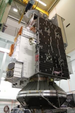
An international satellite that will set a new standard for global precipitation measurements from space has completed a 7,300-mile journey from the United States to Japan, where it now will undergo launch preparations. A U.S. Air Force C-5 transport aircraft carrying the Global Precipitation Measurement (GPM) Core Observatory landed at Kitakyushu Airport, about 600 miles southwest of Tokyo, at approximately 1030 EST Saturday, Nov. 23.

The spacecraft, the size of a small private jet, is the largest satellite ever built at NASA's Goddard Space Flight Center in Greenbelt, MD. It left Goddard inside a large shipping container Nov. 19 and began its journey across the Pacific Ocean Nov. 21 from Joint Base Andrews in Maryland, with a refueling stop in Anchorage, Alaska.

From Kitakyushu Airport, the spacecraft was loaded onto a barge heading to the Japan Aerospace Exploration Agency's (JAXA's) Tanegashima Space Center on Tanegashima Island in southern Japan, where it will be prepared for launch in early 2014 on an H-IIA rocket. "We have been building GPM hardware at Goddard for over four years," said Art Azarbarzin, GPM project manager, who traveled with the spacecraft on its flight to Japan. "We are excited now to get the spacecraft to Tanegashima and looking forward to the launch."

The satellite is designed to pool together precipitation measurements taken by a constellation of orbiting U.S. and international partner satellites, resulting in a single and comprehensive dataset of global precipitation every three hours.

The satellite will measure rain and snow using two science instruments: the GPM Microwave Imager (GMI) and the Dual-frequency Precipitation Radar (DPR). The GMI captures precipitation intensities and horizontal patterns, while the DPR provides insights into the three-dimensional structure of rain, snow and other precipitation particles. Together, these two instruments provide a database of measurements against which other partner satellites' microwave observations can be meaningfully compared and combined to make a global precipitation dataset.

The GPM mission is a partnership led by NASA and JAXA. Goddard built and assembled the satellite. JAXA provided the DPR instrument and launch services. The GPM constellation is a network of satellites from multiple U.S. and international space agencies, including NASA, JAXA, the U.S. Department of Defense's Defense Meteorological Satellite Program, the U.S. National Oceanic and Atmospheric Administration; Japan; the Centre National d'Etudes Spatiales in France; the Indian Space Research Organization; and the European Organization for the Exploitation of Meteorological Satellites.

(GPM Satellite image provided by NASA)

FMI: www.nasa.gov/gpm

Advertisement

More News

Unfortunate... ANN/SportPlane Resource Guide Adds To Cautionary Advisories

The Industry Continues to be Rocked By Some Questionable Operations Recent investigations and a great deal of data has resulted in ANN’s SportPlane Resource Guide’s rep>[...]

ANN FAQ: Turn On Post Notifications

Make Sure You NEVER Miss A New Story From Aero-News Network Do you ever feel like you never see posts from a certain person or page on Facebook or Instagram? Here’s how you c>[...]

ANN's Daily Aero-Term (04.29.24): Visual Approach Slope Indicator (VASI)

Visual Approach Slope Indicator (VASI) An airport lighting facility providing vertical visual approach slope guidance to aircraft during approach to landing by radiating a directio>[...]

ANN's Daily Aero-Term (04.28.24): Airport Marking Aids

Airport Marking Aids Markings used on runway and taxiway surfaces to identify a specific runway, a runway threshold, a centerline, a hold line, etc. A runway should be marked in ac>[...]

ANN's Daily Aero-Linx (04.28.24)

Aero Linx: The Skyhawk Association The Skyhawk Association is a non-profit organization founded by former Skyhawk Pilots which is open to anyone with an affinity for the A-4 Skyhaw>[...]

blog comments powered by Disqus


Advertisement

Advertisement

Podcasts

Advertisement

© 2007 - 2024 Web Development & Design by Pauli Systems, LC