Mon, Jan 18, 2010
Two-Year Program Will Move Satellites To Support Troops
 Officials from the US Strategic Command (STRATCOM) and Air
Force Space Command (AFSPC) recently initiated an effort that will
improve global coverage for users of GPS. The need to support US
and allied military operations in Afghanistan and Iraq, where
terrain in geographically challenging areas can degrade complete
coverage of GPS signals, drove a look for ways to improve signal
coverage.
Officials from the US Strategic Command (STRATCOM) and Air
Force Space Command (AFSPC) recently initiated an effort that will
improve global coverage for users of GPS. The need to support US
and allied military operations in Afghanistan and Iraq, where
terrain in geographically challenging areas can degrade complete
coverage of GPS signals, drove a look for ways to improve signal
coverage.
STRATCOM officials are charged with the responsibility for
providing and maintaining space capabilities to civil, commercial
and military users world-wide. As such, the STRATCOM commander
approved an Air Force-developed approach that benefits not only
military operations, but also all GPS users by taking advantage of
the largest on-orbit GPS constellation in its history.
The current GPS constellation will be optimized to provide
enhanced capability for all GPS users and provide better support to
military forces operating in Afghanistan. Essentially, this plan
will take advantage of today's constellation size and reposition
satellites to improve coverage.
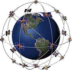
The existing constellation replenishment strategy positions new
GPS satellites close to older satellites. This strategy protects
against possible failing satellites. The current strength of the
constellation will allow the constellation to be spread out and
improve GPS access worldwide.
The initiative will take up to 24 months to fully implement as
satellites are repositioned within the constellation based on
constellation health. The beneficial impact to all GPS users,
including civilian users, will be slowly realized during that time
period. Over the next two years, the number of GPS satellites in
view from any point on earth will increase, potentially increasing
accuracy of GPS receivers.
The STRATCOM and AFSPC team seeks to continually enhance GPS
capability and is committed to meeting and exceeding civilian and
military user requirements for worldwide, 24/7, positioning,
navigation and timing service.
More News
Airport Marking Aids Markings used on runway and taxiway surfaces to identify a specific runway, a runway threshold, a centerline, a hold line, etc. A runway should be marked in ac>[...]
"It is extremely difficult, if not impossible, for manned aircraft to see a drone while conducting crop-enhancing and other aerial applications at low altitudes and high speeds. We>[...]
Aero Linx: The Skyhawk Association The Skyhawk Association is a non-profit organization founded by former Skyhawk Pilots which is open to anyone with an affinity for the A-4 Skyhaw>[...]
“The T-54A benefits from an active Beechcraft King Air assembly line in Wichita, Kansas, where all required METS avionics and interior modifications are installed on the line>[...]
Aero Linx: Aerostar Owners Association The Association offers the Aerostar Owner a unique opportunity to tap an invaluable source of information concerning the care and feeding of >[...]
 ANN's Daily Aero-Term (04.28.24): Airport Marking Aids

