Precision Aerial Using UAS To Survey Drainage System In Texas | Aero-News Network
Aero-News Network
RSS icon RSS feed
podcast icon MP3 podcast
Subscribe Aero-News e-mail Newsletter Subscribe

Airborne Unlimited -- Most Recent Daily Episodes

Episode Date

Airborne-Monday

Airborne-Tuesday

Airborne-Wednesday Airborne-Thursday

Airborne-Friday

Airborne On YouTube

Airborne-Unlimited-05.12.25

Airborne-NextGen-05.13.25

AirborneUnlimited-05.14.25

Airborne-FlightTraining-05.15.25

AirborneUnlimited-05.16.25

Fri, Feb 02, 2018

Precision Aerial Using UAS To Survey Drainage System In Texas

Evaluating Conditions Following Hurricane Harvey

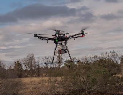
Precision Aerial Compliance Solutions, LLC (Precision Aerial), in partnership with The Woodlands Joint Powers Agency (WJPA) is providing drone LiDAR surveying for portions of The Woodlands drainage system in response to Hurricane Harvey. “The WJPA, on behalf of the Municipal Utility Districts it represents, is taking proactive steps now to help improve drainage during future rainstorms,” said James M. Stinson, PE, general manager for the WJPA.

The WJPA is the central management agency for the ten Municipal Utility Districts (MUDs) that serve The Woodlands in Montgomery County. To evaluate current conditions along portions of Panther Creek and Spring Creek, Precision Aerial will utilize high-end, drone LiDAR to provide the laser assessment for the WJPA. Deploying one of the few drones in the country capable of this type of survey, this will be the first look of its kind at the drainage systems to evaluate current conditions and consider improvements for future preventive measures.

“This is the first use of drone LiDAR by a city or local governmental agency for a drainage survey in Texas and possibly in the whole country,” said Scott McGowan, President, Precision Aerial. “We are uniquely qualified to provide this type of service not only because of our experience, but we operate one of the few drones in the country capable of actually performing this type of scanning. Our cutting-edge LiDAR systems are setting a new industry standard for accuracy and efficiency, and it is something very special.”

Precision Aerial, a Conroe-based aerial data collection and inspection service company, is a member of the LJA Engineering family.

(Image provided with LJA Engineering news release)

FMI: www.lja.com

Advertisement

More News

ANN's Daily Aero-Term (05.19.25): Fuel Remaining

Fuel Remaining A phrase used by either pilots or controllers when relating to the fuel remaining on board until actual fuel exhaustion. When transmitting such information in respon>[...]

ANN's Daily Aero-Linx (05.19.25)

Aero Linx: Piper Aviation Museum Preserving the history and legacy of the Piper Aircraft Corporation and its founding family. In the past three years, the Piper Aviation Museum has>[...]

Klyde Morris (05.16.25)

Klyde Has No Patience... FMI: www.klydemorris.com>[...]

Airborne 05.19.25: Kolb v Tornados, Philippine Mars, Blackhawk Antler Theft

Also: Tentative AirVenture Airshow Lineup, Supersonic Flight Regs, Private Pilot Oral Exam Guide, Boeing Deal The sport aircraft business can be a tough one... especially when Moth>[...]

Airborne-Flight Training 05.15.25: Ray Scholarship, Alto NG, Fighter Training

Also: FedEx Pilots, Army Restructuring, Alaska ANG, Incentive for ATC Hiring EAA Chapter 534 in Leesburg, Florida announced that the 2025 Ray Aviation Scholarship winner is Abdiel >[...]

blog comments powered by Disqus


Advertisement

Advertisement

Podcasts

Advertisement

© 2007 - 2025 Web Development & Design by Pauli Systems, LC