ForeFlight Adds Multiple Features To Mobile, Web Clients | Aero-News Network
Aero-News Network
RSS icon RSS feed
podcast icon MP3 podcast
Subscribe Aero-News e-mail Newsletter Subscribe

Airborne Unlimited -- Most Recent Daily Episodes

Episode Date

Airborne-Monday

Airborne-Tuesday

Airborne-Wednesday Airborne-Thursday

Airborne-Friday

Airborne On YouTube

Airborne-Unlimited-04.01.24

Airborne-Unlimited-04.09.24

Airborne-Unlimited-04.10.24 Airborne-Unlimited-04.11.24

Airborne-Unlimited-04.12.24

Join Us At 0900ET, Friday, 4/10, for the LIVE Morning Brief.
Watch It LIVE at
www.airborne-live.net

Mon, Sep 25, 2017

ForeFlight Adds Multiple Features To Mobile, Web Clients

Improves Flight Planning, Maps, Weather Displays

ForeFlight has released several new features for both its mobile apps and web-based platforms.

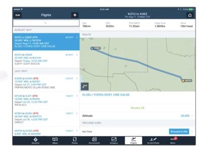
Route Advisor now shows a visual preview of all route options on an interactive map. Quickly tap through the list to highlight each route, then tap "Select Route" to add it to your flight plan. It's simple, easy, and helps you plan faster. ForeFlight's performance planning now supports step climbs. Our advanced flight planning engine calculates the highest possible initial altitude, then automatically creates step climb legs as the aircraft weight decreases. Step climbs are available on all Performance plan levels.

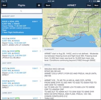
After filing your flight plan in ForeFlight, you will receive a push notification to your device when ATC issues a revised expected route and when adverse weather conditions arise that may affect your flight. Flight Notifications are delivered automatically when you file your flight plan via ForeFlight.

The "Add Next Flight" button in the Flights view makes it faster and easier to plan multi-leg flights by carrying forward departure, aircraft details, payload, fuel policy, and more. In addition, you can now export your flight plan in the official ICAO format and print, email, share via AirDrop, and save a copy in ForeFlight Documents.

The ForeFlight map engine has a significantly upgraded basemap which now renders features (such as major roads, railways, national parks, and political boundaries) more quickly and with sharper depiction. The new Shaded Terrain option uses grayscale shading to depict terrain, providing the same level of detail as the Colored Terrain option with less visual distraction.

Scheduled Flight Search in Maps View allows the user to enter a tail number, aircraft call sign, or commercial flight number into the Maps view search box to see recently filed flight plans for aircraft that are either currently enroute or will depart in the next 24 hours.

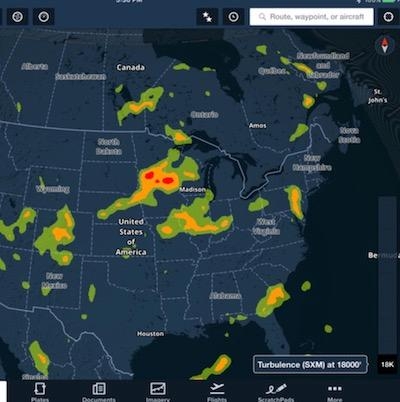
Users that fly with the SiriusXM SXAR1 aviation receiver will now see Icing, Turbulence, and Surface Analysis layers as part of your SiriusXM Pilot for ForeFlight subscription.

The "Add Next Entry" button in Logbook allows you to quickly add a follow-up entry for any existing flight in your logbook.

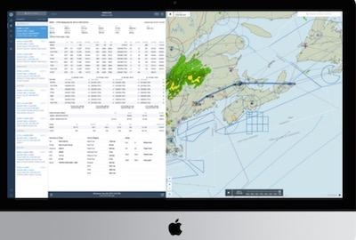
For the web-based platform, an improved NavLog interface that expands for better viewing and also syncs between web and mobile, an "Add Next Flight" button to improve multi-leg flight planning, and (much) faster radar loading.

(Source: ForeFlight news letter. Images provided)

FMI: foreflight.com


Advertisement

More News

ANN's Daily Aero-Linx (04.13.24)

Aero Linx: Florida Antique Biplane Association "Biplanes.....outrageous fun since 1903." That quote really defines what the Florida Antique Biplane Association (FABA) is all about.>[...]

ANN's Daily Aero-Term (04.13.24): Beyond Visual Line Of Sight (BVLOS)

Beyond Visual Line Of Sight (BVLOS) The operation of a UAS beyond the visual capability of the flight crew members (i.e., remote pilot in command [RPIC], the person manipulating th>[...]

Airborne 04.09.24: SnF24!, Piper-DeltaHawk!, Fisher Update, Junkers

Also: ForeFlight Upgrades, Cicare USA, Vittorazi Engines, EarthX We have a number of late-breaking news highlights from the 2024 Innovation Preview... which was PACKED with real ne>[...]

Aero-News: Quote of the Day (04.14.24)

“For Montaer Aircraft it is a very prudent move to incorporate such reliable institution as Ocala Aviation, with the background of decades in training experience and aviation>[...]

ANN's Daily Aero-Term (04.14.24): Maximum Authorized Altitude

Maximum Authorized Altitude A published altitude representing the maximum usable altitude or flight level for an airspace structure or route segment. It is the highest altitude on >[...]

blog comments powered by Disqus


Advertisement

Advertisement

Podcasts

Advertisement

© 2007 - 2024 Web Development & Design by Pauli Systems, LC