Seattle Avionics' Debuts Integrated PC Software System | Aero-News Network
Aero-News Network
RSS icon RSS feed
podcast icon MP3 podcast
Subscribe Aero-News e-mail Newsletter Subscribe

Airborne Unlimited -- Most Recent Daily Episodes

Episode Date

Airborne-Monday

Airborne-Tuesday

Airborne-Wednesday Airborne-Thursday

Airborne-Friday

Airborne On YouTube

Airborne-Unlimited-04.01.24

Airborne-Unlimited-04.16.24

Airborne-FlightTraining-04.17.24 Airborne-Unlimited-04.11.24

Airborne-Unlimited-04.12.24

Join Us At 0900ET, Friday, 4/10, for the LIVE Morning Brief.
Watch It LIVE at
www.airborne-live.net

Sat, Jul 23, 2005

Seattle Avionics' Debuts Integrated PC Software System

Combines Pre-Flight, Enroute Planning Tools, Moving Map, Plates, Weather

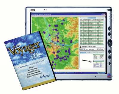
We were promised VERY cool developments for Oshkosh when we talked with the Seattle Aviionics folks at Arlington 2005 and it appears that they weren't fibbing. Seattle Avionics Software is out with what it calls the Voyager Flight Software System.

The company says all of the components integrate into a seamless single application custom-tailored to each pilot's needs. As needs change, additional tools can be downloaded and integrated any time in the future.

Voyager is a fully integrated system unlike new "suites" of old technology flight planning and moving map applications just bundled together. Such solutions are awkward and require users to transfer data between individual applications, especially cumbersome in the cockpit. And unlike expensive "one-size-fits-all" solutions, the Voyager Flight Software System allows pilots to select only the tools and functionality they want and add more as their needs change.

According to Steve Podradchik, Seattle Avionics Software CEO, "Our mission has always been to use technology to make flying safer and more fun. To that end, we feel we've broken new ground with the Voyager Flight Software System in that it automatically adapts to pilots' needs as their situation changes with phases of flight. For example, in addition to showing basic GPS information, Voyager's GlassView moving map keeps you safe by automatically displaying nearest airport, navaid and airspace information as your position changes and shows detailed airport and procedure information as you approach your destination."

Seattle Avionics Software is a technological leader in aviation software. Voyager is the only flight software written from the ground up with the Microsoft.Net Framework development tools, providing many significant advantages over competitive offerings. This development environment allows true integration of pilot tools, such as a planner or moving map, into a single application. It also allows updates to the Voyager program and additional innovative features to be rolled out more frequently, and offers seamless background Internet connectivity and multi-threading. Voyager takes full advantage of Intel's new HT (HyperThreading) technology.

FMI: www.seattleavionics.com

Advertisement

More News

ANN's Daily Aero-Linx (04.15.24)

Aero Linx: International Flying Farmers IFF is a not-for-profit organization started in 1944 by farmers who were also private pilots. We have members all across the United States a>[...]

Classic Aero-TV: 'No Other Options' -- The Israeli Air Force's Danny Shapira

From 2017 (YouTube Version): Remembrances Of An Israeli Air Force Test Pilot Early in 2016, ANN contributor Maxine Scheer traveled to Israel, where she had the opportunity to sit d>[...]

Aero-News: Quote of the Day (04.15.24)

"We renegotiated what our debt restructuring is on a lot of our debts, mostly with the family. Those debts are going to be converted into equity..." Source: Excerpts from a short v>[...]

Airborne 04.16.24: RV Update, Affordable Flying Expo, Diamond Lil

Also: B-29 Superfortress Reunion, FAA Wants Controllers, Spirit Airlines Pulls Back, Gogo Galileo Van's Aircraft posted a short video recapping the goings-on around their reorganiz>[...]

ANN's Daily Aero-Term (04.16.24): Chart Supplement US

Chart Supplement US A flight information publication designed for use with appropriate IFR or VFR charts which contains data on all airports, seaplane bases, and heliports open to >[...]

blog comments powered by Disqus


Advertisement

Advertisement

Podcasts

Advertisement

© 2007 - 2024 Web Development & Design by Pauli Systems, LC