Thu, Feb 04, 2010
Scientists Hope To Be Able To Measure Tectonic Plate
Movements
JPL's Uninhabited Aerial Vehicle Synthetic Aperture Radar
(UAVSAR) captured this false-color composite image of the city of
Port-au-Prince, Haiti, and the surrounding region on Jan. 27, 2010.
Port-au-Prince is visible near the center of the image. The large
dark line running east-west near the city is the main airport.
UAVSAR left NASA's Dryden Flight Research Center in Edwards, CA,
January 25, aboard a modified NASA Gulfstream III aircraft on a
three-week campaign that will also take it to Central America.
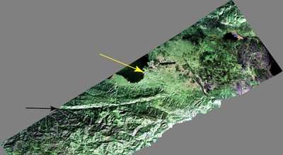
Photo Courtesy JPL
Shortly before 1700 local time on January 12,a magnitude 7.0
earthquake struck southern Haiti. The earthquake's epicenter was
about 25 kilometers (15 miles) west-southwest of Port-au-Prince,
close to the west (left) edge of this image (yellow arrow). The
large linear east-west valley in the mountains south of the city is
the location of the major active fault zone responsible for the
earthquake: the Enriquillo-Plantain Garden fault (black arrow). The
fault extends from the western tip of Haiti past Port-au-Prince
into the Dominican Republic to the east of this image. Historical
records show that the southern part of Haiti was struck by a series
of large earthquakes in the 1700s, and geologists believe those
were also caused by ruptures on this fault zone.
Satellite interferometric synthetic aperture radar measurements
show that the January 12 earthquake ruptured a segment of the fault
extending from the epicenter westward over a length of about 40
kilometers (25 miles), leaving the section of the fault in this
image unruptured. The earthquake has increased the stress on this
eastern section of the fault south of Port-au-Prince and the
section west of the rupture. This has significantly increased the
risk of a future earthquake, according to a recent report by the
U.S. Geological Survey.
This image will be combined with other images of the same area
to be acquired later this month and in the future in order to
measure the motion of Earth's surface during the time between
images using a technique called interferometry.The interferometric
measurements will allow scientists to study the pressures building
up and being released on the fault at depth.
More News
Also: B-29 Superfortress Reunion, FAA Wants Controllers, Spirit Airlines Pulls Back, Gogo Galileo Van's Aircraft posted a short video recapping the goings-on around their reorganiz>[...]
Light Gun A handheld directional light signaling device which emits a brilliant narrow beam of white, green, or red light as selected by the tower controller. The color and type of>[...]
"The journey to this achievement started nearly a decade ago when a freshly commissioned Gentry, driven by a fascination with new technologies and a desire to contribute significan>[...]
"Our driven and innovative team of military and civilian Airmen delivers combat power daily, ensuring our nation is ready today and tomorrow." Source: General Duke Richardson, AFMC>[...]
Aircraft Conflict Predicted conflict, within EDST of two aircraft, or between aircraft and airspace. A Red alert is used for conflicts when the predicted minimum separation is 5 na>[...]
 Airborne 04.16.24: RV Update, Affordable Flying Expo, Diamond Lil

