U.S. Army, Lockheed Martin Bring Enhanced Capability To Apache Cockpit | Aero-News Network
Aero-News Network
RSS icon RSS feed
podcast icon MP3 podcast
Subscribe Aero-News e-mail Newsletter Subscribe

Airborne Unlimited -- Most Recent Daily Episodes

Episode Date

Airborne-Monday

Airborne-Tuesday

Airborne-Wednesday Airborne-Thursday

Airborne-Friday

Airborne On YouTube

Airborne-Unlimited-04.01.24

Airborne-Unlimited-04.09.24

Airborne-Unlimited-04.10.24 Airborne-Unlimited-04.11.24

Airborne-Unlimited-04.12.24

Join Us At 0900ET, Friday, 4/10, for the LIVE Morning Brief.
Watch It LIVE at
www.airborne-live.net

Mon, Feb 24, 2014

U.S. Army, Lockheed Martin Bring Enhanced Capability To Apache Cockpit

Test Modernized Day Sensor Assembly At Redstone Arsenal

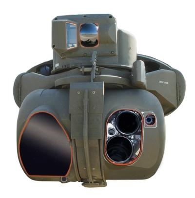
Team Apache Sensors, including the U.S. Army's Apache Attack Helicopter Project Management Office and Aviation Flight Test Directorate and Lockheed Martin  conducted a test flight of the Apache AH-64E Modernized Day Sensor Assembly (M-DSA) during an event at Redstone Arsenal in Huntsville, AL.

The test flight demonstrated the maturity of M-DSA and the enhanced capabilities it brings to the Modernized Target Acquisition Designation Sight/Pilot Night Vision Sensor (M-TADS/PNVS), the precision targeting and pilotage system for the AH-64D/E Apache helicopter.

"We are looking forward to the reliability and maintainability improvements that this laser will bring to the M-TADS system," said Lt. Col. Steven Van Riper, Apache Sensors product manager. "This system will help to further reduce the burden on our aircrews, as they will be able to reap the benefits of the performance improvements."

M-DSA increases M-TADS/PNVS designation and ranging capabilities to fully accommodate current weapons and those planned for the future. The upgraded sensor enables Apache pilots to see high-resolution, high-definition near infrared and color imagery on cockpit displays. An additional field of view allows image blending with the M-TADS forward-looking infrared, and enables pilots to see civilian and military lighting on a single display more clearly. M-DSA also provides a new laser pointer marker that improves coordination with ground troops and an updated multi-mode laser with eye-safe lasing capability that supports flight in urban environments and critical training exercises.

"M-DSA completes the modernization of the M-TADS/PNVS," said Matt Hoffman, M-TADS/PNVS director at Lockheed Martin Missiles and Fire Control. "The new capabilities provided by M-DSA, such as color in the cockpit and an enhanced laser pointer marker, will support rapid target identification and coordination, as well as improve safety and system reliability for U.S. Army Apache aircrews."

Lockheed Martin, the Apache Project Office and the Army Flight Test Directorate will spend the next few months validating M-DSA capabilities at Redstone Arsenal and Yuma Proving Grounds, AZ.

(M-DSA image provided by Lockheed Martin)

FMI: www.lockheedmartin.com 

Advertisement

More News

ANN's Daily Aero-Linx (04.13.24)

Aero Linx: Florida Antique Biplane Association "Biplanes.....outrageous fun since 1903." That quote really defines what the Florida Antique Biplane Association (FABA) is all about.>[...]

ANN's Daily Aero-Term (04.13.24): Beyond Visual Line Of Sight (BVLOS)

Beyond Visual Line Of Sight (BVLOS) The operation of a UAS beyond the visual capability of the flight crew members (i.e., remote pilot in command [RPIC], the person manipulating th>[...]

Airborne 04.09.24: SnF24!, Piper-DeltaHawk!, Fisher Update, Junkers

Also: ForeFlight Upgrades, Cicare USA, Vittorazi Engines, EarthX We have a number of late-breaking news highlights from the 2024 Innovation Preview... which was PACKED with real ne>[...]

Aero-News: Quote of the Day (04.14.24)

“For Montaer Aircraft it is a very prudent move to incorporate such reliable institution as Ocala Aviation, with the background of decades in training experience and aviation>[...]

ANN's Daily Aero-Term (04.14.24): Maximum Authorized Altitude

Maximum Authorized Altitude A published altitude representing the maximum usable altitude or flight level for an airspace structure or route segment. It is the highest altitude on >[...]

blog comments powered by Disqus


Advertisement

Advertisement

Podcasts

Advertisement

© 2007 - 2024 Web Development & Design by Pauli Systems, LC