"Operation Ice Bridge" Employs A Flying Laboratory
Scientists returned this week to the Southern Hemisphere where
NASA's Operation IceBridge mission is set to begin its second year
of airborne surveys over Antarctica. The mission monitors the
region's changing sea ice, ice sheets and glaciers.

Researchers will make flights from Punta Arenas, Chile, on
NASA's DC-8, a 157-foot airborne laboratory equipped with a suite
of seven instruments. The focus is to re-survey areas that are
undergoing rapid change and to embark on new lines of
investigation.
"We are excited to learn how the glaciers and sea ice have
changed since last year's campaign," said Michael Studinger,
IceBridge project scientist at NASA's Goddard Space Flight Center
in Greenbelt, MD. "We also are going to be mapping uncharted
regions that will allow us to better assess future behavior of the
Antarctic ice sheets and sea ice."
IceBridge science flights are scheduled to begin this weekend
and continue through mid-November. Flights will take off from Punta
Arenas and cross the Southern Ocean to reach destinations including
West Antarctica, the Antarctic Peninsula and coastal areas. Each
flight lasts about 11 hours.

NASA DC-8 Over Santago, Chile NASA Image
Instruments for the 2010 Antarctic campaign are the same as
those flown in 2009. A laser instrument will map and identify
surface changes. Radar instruments will penetrate the snow and ice
to see below the surface, providing a profile of ice
characteristics and also the shape of the bedrock supporting it. A
gravity instrument will measure the shape of seawater-filled
cavities at the edge of some major fast-moving glaciers.
Using these tools, researchers will survey targets of on-going
and potential rapid change, including the West Antarctic Ice Sheet,
which is the area that has the greatest potential to rapidly
increase sea level. Another concern is that the ice sheet is below
sea level, adding to its instability.

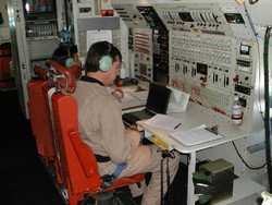
NASA DC-8 Interior Console NASA Image
Revisiting previously flown areas, scientists can begin to
quantify the magnitude of changes to land ice. Pine Island Glacier,
the largest ice stream in West Antarctica with significant
potential contribution to sea level rise, has long been a primary
target for sustained observations.
Satellite data, most recently from NASA's Ice, Cloud and land
Elevation Satellite (ICESat) have shown dramatic thinning there of
up to 10 meters per year in places. Previous IceBridge flights
mapped the surface of the glacier and unusual features beneath it,
providing clues to the glacier's rapid retreat and ice loss.
In addition to flying previous lines over the glacier, the
IceBridge team plans to fly a new horseshoe pattern to sample the
tributaries feeding into Pine Island Glacier's main trunk. Other
new flight lines will further explore the Antarctic Peninsula to
map new targets, including the George VI Ice Shelf, above and below
the ice.
Three high-priority flights are aimed at measuring sea ice,
including a plan to map and measure sea ice across the Weddell Sea.
Scientists want to know why sea ice in Antarctica is growing in
extent, unlike sea ice in the Arctic, which is declining in extent.
Current theories range from ozone depletion to changing ocean
dynamics.

NASA DC-8 NASA Image
Other flights are being planned to be coordinated with existing
space and ground-based missions, such as the European Space
Agency's ice-observing Cryosat-2 satellite and European ship-based
research. Overlapping measurements help researchers calibrate
instruments and boost confidence in the resulting observations.
"A concerted effort like this will allow us to produce long time
series of data spanning from past satellite missions to current and
future missions," Studinger said. "This is only possible through
international collaboration. We are excited to have many
opportunities to work with our international partners during the
upcoming campaign."
 ANN's Daily Aero-Linx (04.16.24)
 Aero-News: Quote of the Day (04.16.24)
 Airborne 04.10.24: SnF24!, A50 Heritage Reveal, HeliCycle!, Montaer MC-01
 Airborne 04.12.24: SnF24!, G100UL Is Here, Holy Micro, Plane Tags
 Airborne-Flight Training 04.17.24: Feds Need Controllers, Spirit Delay, Redbird


