U-2 Goes Eye-To-Eye With Hurricanes | Aero-News Network
Aero-News Network
RSS icon RSS feed
podcast icon MP3 podcast
Subscribe Aero-News e-mail Newsletter Subscribe

Airborne Unlimited -- Most Recent Daily Episodes

Episode Date

Airborne-Monday

Airborne-Tuesday

Airborne-Wednesday Airborne-Thursday

Airborne-Friday

Airborne On YouTube

Airborne-Unlimited-04.01.24

Airborne-Unlimited-04.16.24

Airborne-FlightTraining-04.17.24 Airborne-Unlimited-04.11.24

Airborne-Unlimited-04.12.24

Join Us At 0900ET, Friday, 4/10, for the LIVE Morning Brief.
Watch It LIVE at
www.airborne-live.net

Tue, Sep 13, 2005

U-2 Goes Eye-To-Eye With Hurricanes

It rips apart everything in its path. It destroys houses, businesses, lives and families. These past couple of weeks, America has been greatly devastated by it.

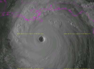
Capt. Jeff Wright, a U-2S aircraft commander with the 99th Reconnaissance Squadron, is one of few Airmen who was able to see the vast devastation of Hurricane Katrina from a bird’s point of view.

Captain Wright flew a U-2 to take pictures of alternate routes out of cities where citizens were trying to evacuate. The pictures were developed here and later sent to the Federal Emergency Management Agency.

Hurricane Katrina is not Captain Wright’s first hurricane. He has flown into the “eye” of more than 60 hurricanes and tropical storms.

From 1996 through 2002, Captain Wright was part of Hurricane Hunters, the 53rd Weather Reconnaissance Reserve Squadron at Keesler Air Force Base, Miss.

He flew into Hurricane Mitch, the 1998 hurricane that devastated much of Central America and killed about 10,000 people, as well as Hurricane Francis, which destroyed many parts of Florida in 2004.

The Air Force Reserve group of pilots flies information-gathering missions into the center of hurricanes and tropical storms.

They collect information such as a storm’s wind speed, pressure, center, temperature and humidity. This data is used to narrow the area of evacuation to save money and lives. For every one-mile radius that is evacuated, expenses total to about $1 million, Captain Wright said.

“It’s sad when there is nothing you can do,” he said. By obtaining useful information about the storm, pilots help relief efforts greatly, he said

The Hurricane Hunter pilots fly aboard a WC-130 Hercules. The WC-130 Hercules is a high-wing, medium-range aircraft flown by the Air Force Reserve Command for weather reconnaissance missions.

Sensors installed on the aircraft measure per second outside temperature, humidity, absolute altitude of the aircraft, pressure altitude, wind speed and direction. This information, along with an evaluation of other meteorological conditions, turbulence, icing, radar returns and visibility, is encoded by the onboard meteorologist and transmitted by satellite to the National Weather Services' National Hurricane Center in Miami.

Unfortunately, natural disasters will continue to destroy many lives and lands. But Hurricane Hunger efforts minimize the damage by providing enhanced warning of the storm and in-depth facts about it. [ANN Salutes Airman 1st Class Robert Biermann, 9th Reconnaissance Wing Public Affairs]

FMI: www.af.mil

Advertisement

More News

ANN's Daily Aero-Linx (04.15.24)

Aero Linx: International Flying Farmers IFF is a not-for-profit organization started in 1944 by farmers who were also private pilots. We have members all across the United States a>[...]

Classic Aero-TV: 'No Other Options' -- The Israeli Air Force's Danny Shapira

From 2017 (YouTube Version): Remembrances Of An Israeli Air Force Test Pilot Early in 2016, ANN contributor Maxine Scheer traveled to Israel, where she had the opportunity to sit d>[...]

Aero-News: Quote of the Day (04.15.24)

"We renegotiated what our debt restructuring is on a lot of our debts, mostly with the family. Those debts are going to be converted into equity..." Source: Excerpts from a short v>[...]

Airborne 04.16.24: RV Update, Affordable Flying Expo, Diamond Lil

Also: B-29 Superfortress Reunion, FAA Wants Controllers, Spirit Airlines Pulls Back, Gogo Galileo Van's Aircraft posted a short video recapping the goings-on around their reorganiz>[...]

ANN's Daily Aero-Term (04.16.24): Chart Supplement US

Chart Supplement US A flight information publication designed for use with appropriate IFR or VFR charts which contains data on all airports, seaplane bases, and heliports open to >[...]

blog comments powered by Disqus


Advertisement

Advertisement

Podcasts

Advertisement

© 2007 - 2024 Web Development & Design by Pauli Systems, LC