Thu, Oct 30, 2014
Over 57,000 Square Miles Mapped And Analyzed
The Australian government says that it is progressing in its search for Malaysian Airlines Flight 370, a Boeing 777 that vanished in March of this year.
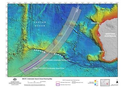
The search team, led by the Australian Transport Safety Bureau (ATSB), says it has mapped and analyzed over 150,000 square kilometers (approx. 57,000 sq miles) ... which it says is "sufficient area having been surveyed for the underwater search to take place." According to the update, the sea floor in the search area had never previously been mapped in detail. Before the sidescan sonar work to locate MH370 could begin, it was necessary to conduct a bathymetric survey to ensure that the equipment could be operated safely. The survey vessel Fugro Equator and the Chinese survey vessel Zhu Khezhen collaborated on survey operations, until Zhu Khezhen completed her assignment on September 20 and returned to China.
The ATSB says that while it is impossible to determine with certainty where the aircraft may have entered the water, the available data and analysis indicate that the most likely location lies close to a long but narrow arc in the southern Indian Ocean (where the aircraft last communicated with a ground station through a satellite). This is where the aircraft is assessed to have run out of fuel. Complex and ground-breaking technical analysis of the limited satellite communications data and aircraft flight information has been developed and refined since the disappearance of MH370. That work has concentrated on determining the area on the seventh arc that the aircraft was most likely to have reached, enabling a prioritized search effort.
After mapping, the ATSB says that Over 2,500 square kilometres (approx 965 sq miles) of the sea floor have been searched so far.
In addition to locating the aircraft, the underwater search aims to identify any crucial evidence (such as aircraft wreckage and flight recorders) to assist with the Malaysian investigation. The ATSB has utilized the data from the bathymetric survey work to prepare the initial plan for the underwater search, to be followed and referred to by all parties involved. The plan includes search timings, methods, procedures, safety precautions and search areas. The initial search areas have been allocated to the different vessels with the aim of positively identifying and mapping the debris field of MH370.
(ATSB Image)
More News
"Sometimes, growth makes it easy to miss the little things, and today's "little guy" is smarting more than ever just looking at the price tags of "cheap" aircraft. Poberezny, seein>[...]
Aero Linx: Space Medicine Association (SMA) The Space Medicine Association of the Aerospace Medical Association is organized exclusively for charitable, educational, and scientific>[...]
Also: Martha King Scholarship, Montaer Grows, Textron Updates Pistons, FlySto The FAA is hiring thousands of air traffic controllers, but the window to apply will only be open for >[...]
Also: B-29 Superfortress Reunion, FAA Wants Controllers, Spirit Airlines Pulls Back, Gogo Galileo Van's Aircraft posted a short video recapping the goings-on around their reorganiz>[...]
Also: Flight Club, Jet Shades, MyGoFlight’s FlightFlix Acquisition FIFTY YEARS! What a milestone for the aviation world’s master aero-education duo! John, Martha, along>[...]
 Aero-News: Quote of the Day (04.17.24)

