Introducing Premium Worldwide Navigation Data Plus European And Canadian Charts
Garmin International has announced worldwide coverage of the Garmin Pilot application for iPad and iPhone, which provides flight planning capabilities, comprehensive weather information and full-featured navigation. Pilots also have access to expanded coverage of European charts in a single application, including geo-referenced FliteCharts and SafeTaxi airport diagrams. Additionally, new features such as FastFind and Smart Airspace offer customers efficient flight planning capabilities, quick waypoint entry and intuitive airspace navigation.
“Flight planning applications in the cockpit continue to grow in popularity and Garmin Pilot incorporates game-changing features like worldwide flight planning, all-inclusive weather coverage and navigation information,” said Carl Wolf, vice president of aviation sales and marketing. “Customers around the globe have been asking for a premium, feature-rich application and Garmin has delivered, backed by decades of industry-leading experience in navigation. Garmin Pilot incorporates a familiar user-interface and innovative features so pilots have access to the information they need to make informed decisions.”
Garmin Pilot streamlines pre-flight planning, allowing pilots to review weather and flight plan, as well as download and review charts ahead of each flight. Rich, interactive maps integrated within Garmin Pilot offer worldwide coverage using a combination of both Jeppesen and Garmin’s navigation data, so flight planning is simple for pilots around the globe. Highly configurable moving maps allow pilots to choose between track-up or north-up orientation. In track-up mode, labels are always upright and easy to read because map information is displayed in the direction of flight. Further customization allows pilots to tailor maps to their personal preferences including map color, visibility range, display of NAVAIDs and more. Unique to Garmin Pilot, a radial menu provides easy on-screen access to create user waypoints, navigate direct-to, graphically edit flight plans, view weather conditions and airport information at a glance.
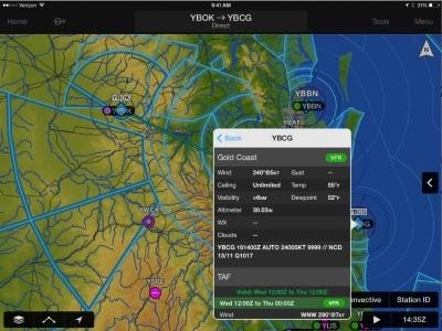
Weather information including METARs, TAFs, AIRMETs, SIGMETs, NOTAMs and winds aloft may be displayed graphically as an overlay on the moving map page, within the airport information page and as a widget in split-screen mode using an iPad. Text-based weather products may be viewed in split-screen mode and using the NavTrack feature, so pilots can easily see and intuitively understand weather trends along their route. Additionally, radar and satellite imagery for Western Europe, Canada, Australia and the U.S. provide pilots with even more weather products so its easy to determine if precipitation or cloud cover will impact a particular flight.
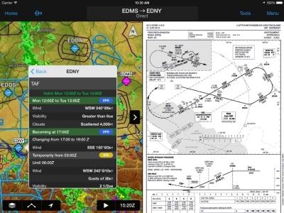
Garmin Pilot reduces the amount of paper charts needed to complete a flight, offering pilots electronic flight bag capabilities around the globe. Configurable maps give customers the option to customize the display of charts, weather overlays, terrain and obstacles in split screen view, so a variety of information can be displayed simultaneously. Visual Reporting Points (VRPs), commonly found in Europe are overlaid on the moving map page, allowing pilots to easily report their position. Customers also have access to optional geo-referenced European FliteCharts (terminal procedures) for select countries. Garmin Pilot optionally supports European VFR and IFR charts with VFR data sourced directly from Deutsche Flugsicherung (DFS) and IFR charts from Eurocontrol. Pilots may easily navigate unfamiliar airports with SafeTaxi, which conveniently displays geo-referenced airport diagrams throughout portions of Europe, directly on the moving map. FliteCharts and SafeTaxi coverage is further extended into Canada
and includes approaches, departures and arrival procedures. Global terrain, as well as U.S. and Europe obstacle alerting available within Garmin Pilot, offers an enhanced level of situational awareness in even the most challenging terrain environments.
Similar to features found within Garmin avionics, Smart Airspace is available within Garmin Pilot, so it is easy to identify what airspace lies ahead. Smart Airspace conveniently highlights the airspace nearest the aircraft’s current altitude and de-emphasizes non-pertinent airspace so pilots can quickly identify their location relative to the airspace around them. Additionally, the altitude filter removes airspace above the user-defined altitude. As customers enter flight plan information, FastFind incorporates predictive logic to suggest airports and waypoints using current GPS location so entering flight plan information is faster and easier. Quick flight plan entry is possible with FastFind, which automatically begins searching for the nearest identifier as an airport or waypoint is entered within the flight plan.

Garmin Pilot incorporates sophisticated graphics modeling to create a virtual topographic landscape to create 3D Vision, offering a clear 3D depiction of ground, water, terrain features and more. 3D Vision is transformed when paired with the GDL 39 3D portable ADS-B datalink receiver, which superimposes back-up aircraft attitude information on top of the Garmin synthetic vision (SVX) display. Outside of the U.S., the GDL 39 3D offers industry-leading GPS, attitude information and air-to-air ADS-B traffic, providing pilots with even more information in the cockpit. Aircraft attitude information is also available on the aircraft panel page, which displays back-up attitude, GPS-derived altitude and airspeed, as well as HSI course guidance.
Garmin Pilot 6.2 is available immediately as a free update, providing existing customers access to Smart Airspace, FastFind and optional worldwide coverage. For new customers, Garmin Pilot is available in the Apple App Store as a free download for the first 30 days. After the 30-day trial period, customers may purchase an annual subscription of Garmin Pilot featuring worldwide coverage starting at $199.99. Pilots may purchase optional FliteCharts, SafeTaxi, DFS and IFR charts starting at $49.99. Garmin Pilot Canada Premium includes Garmin FliteCharts and SafeTaxi diagrams for Canada, text-based weather products, as well as radar and satellite imagery for the U.S. and Canada and is expected to become available in August for $149.99.
(Images provided by Garmin)
 ANN's Daily Aero-Term (04.20.24): Light Gun

