NASA Maps Beirut Blast Damage | Aero-News Network
Aero-News Network
RSS icon RSS feed
podcast icon MP3 podcast
Subscribe Aero-News e-mail Newsletter Subscribe

Airborne Unlimited -- Most Recent Daily Episodes

Episode Date

Airborne-Monday

Airborne-Tuesday

Airborne-Wednesday Airborne-Thursday

Airborne-Friday

Airborne On YouTube

Airborne-Unlimited-04.22.24

Airborne-Unlimited-04.16.24

Airborne-FlightTraining-04.17.24 Airborne-AffordableFlyers-04.18.24

Airborne-Unlimited-04.19.24

Join Us At 0900ET, Friday, 4/10, for the LIVE Morning Brief.
Watch It LIVE at
www.airborne-live.net

Sun, Aug 09, 2020

NASA Maps Beirut Blast Damage

Satellite-Derived Synthetic Aperture Radar Data Shows Massive Effect

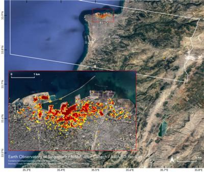
NASA's Advanced Rapid Imaging and Analysis (ARIA) team, in collaboration with the Earth Observatory of Singapore, used satellite-derived synthetic aperture radar data to map the likely extent of damage from a massive Aug. 4 explosion in Beirut.

Synthetic aperture radar data from space shows ground surface changes from before and after a major event like an earthquake. In this case, it is being used to show the devastating result of an explosion.

On the map, dark red pixels – like those present at and around the Port of Beirut – represent the most severe damage. Areas in orange are moderately damaged and areas in yellow are likely to have sustained somewhat less damage. Each colored pixel represents an area of 30 meters.

Maps like this one can help identify badly damaged areas where people may need assistance. The explosion occurred near the city's port. It claimed more than 150 lives and is estimated to have caused billions of dollars' worth of damage.

The map contains modified Copernicus Sentinel data processed by ESA (European Space Agency) and analyzed by ARIA team scientists at NASA JPL, Caltech, and Earth Observatory of Singapore. Located in Pasadena, California, Caltech manages JPL for NASA.

FMI: https://aria.jpl.nasa.gov/

Advertisement

More News

ANN's Daily Aero-Term (04.20.24): Light Gun

Light Gun A handheld directional light signaling device which emits a brilliant narrow beam of white, green, or red light as selected by the tower controller. The color and type of>[...]

Aero-News: Quote of the Day (04.20.24)

"The journey to this achievement started nearly a decade ago when a freshly commissioned Gentry, driven by a fascination with new technologies and a desire to contribute significan>[...]

ANN's Daily Aero-Linx (04.21.24)

Aero Linx: JAARS, Inc. For decades now, we’ve landed planes on narrow rivers and towering mountains. We’ve outfitted boats and vehicles to reach villages that rarely se>[...]

Aero-News: Quote of the Day (04.21.24)

"Our driven and innovative team of military and civilian Airmen delivers combat power daily, ensuring our nation is ready today and tomorrow." Source: General Duke Richardson, AFMC>[...]

ANN's Daily Aero-Term (04.21.24): Aircraft Conflict

Aircraft Conflict Predicted conflict, within EDST of two aircraft, or between aircraft and airspace. A Red alert is used for conflicts when the predicted minimum separation is 5 na>[...]

blog comments powered by Disqus


Advertisement

Advertisement

Podcasts

Advertisement

© 2007 - 2024 Web Development & Design by Pauli Systems, LC