Aircraft Being Evaluated During The First Week Of June
Texas A&M University-Corpus Christi is conducting test flights this week from the Port Mansfield airport through the University’s Lone Star Unmanned Aircraft Systems Center.
A launch in the dark and shoreline flights that match on-the-ground surveying are planned for this round of unmanned aircraft flights.
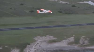
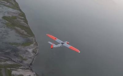
The missions will fly at altitudes up to 3,000 feet and over a distance of 18 miles. The craft, an RS-16, is the University’s largest unmanned aircraft vehicle (UAV), with a wingspan of nearly 13 feet and a maximum weight of 85 pounds. It launches with a pneumatic catapult and lands on its belly.
The University has conducted regular flights of its RS-16 since 2011.
The week’s mission included an early morning launch in the dark on Tuesday, said Dr. David Bridges, Associate Professor of Mechanical Engineering and Director of the University’s UAS Program. This flight used an infrared camera, and tested how drones could be ideal for wildlife inventory, monitoring populations that are more active at night, such as ocelots, an endangered species with fewer than 130 individuals in Texas.
One planned sortie called for the aircraft to fly over the Gulf of Mexico and the Laguna Madre, while Dr. Paul Zimba, Director of the Center for Coastal Studies at A&M-Corpus Christi, and his crew will be at the water’s edge to see how drone-collected imagery compares with shoreline surveys traditionally used to determine property lines. This research seeks to further define a hot topic in Texas, determining the exact line between private and state land in property disputes.
Using UAS data can expand the scope of what his crew of five is able to do.
“We could map 18 miles of the beach using the UAS,” he said. “We couldn’t do that on the ground without an army of 10 crews working simultaneously!”
Zimba’s crew will visually inspect the algae lines and take biological samples to determine if there are specific algae that can be used to indicate the high water line, a key marker in figuring the property line. The drone will capture images of the same area, and a larger area, allowing Zimba to see if that data is equally as accurate as a ground survey.
Students from the Geographic Information Science and Geospatial Surveying Engineering Program also plan to take measurements along the Gulf shoreline and of the dune height for comparison with aerial data collected from the RS-16.
“A&M-Corpus Christi is proud to be at the forefront of this new intersecting field of aerospace engineering and geospatial science,” said Dr. Luis Cifuentes, the University’s Vice President of Research, Commercialization and Outreach and the Interim Director of the Lone Star Center. “Our researchers find great value in collecting aerial data with UAS. It will transform how we learn about erosion, changing shorelines and the impacts of sea level rise and severe weather.”
Researchers currently rely on satellite data or ground- and water-based surveys that can be logistically complicated to conduct and require several crew members. Satellites can be expensive and don’t provide the frequency of data sometimes required.
“The capabilities of UAS are particularly relevant with hurricane season upon us. Imagine being able to send a swarm of UAVs to map a coastal community hours before an approaching storm and immediately after impact,” said Dr. Michael Starek, Assistant Professor of Geospatial Surveying Engineering. “We could rapidly assess damages to guide rescue and repair efforts, even allowing crews to be sent right away as opposed to hours or days delay. In hurricane response scenarios where time is of the essence, this is critical information to help mitigate loss of life and property.”
The Lone Star UAS Center will report the results of the latest tests to the FAA as part of its duties as a federal test site. The tests are designed to safely integrate UAS into the national airspace, including air traffic control and communications, developing protocols for dealing with runways in use by piloted craft and ensuring air traffic control communications between the UAS and Mission Control Center.
While the test site designation does not come with federal funding, studies indicate an economic impact of about $6.5 billion and 8,256 jobs statewide in the decade following full integration of UAS into the national airspace system.
(Images Texas A&M YouTube video)
 ANN's Daily Aero-Linx (04.17.24)

