New Future For ILS-Like Approaches To Airports EVERYWHERE
 Talk about your turn-ons... The FAA
officially turned on GPS-WAAS at 12:01 a.m. (EDT) Thursday morning.
WAAS will provide ILS-like precision approaches to thousands of
general aviation airports that don't have them today.
Talk about your turn-ons... The FAA
officially turned on GPS-WAAS at 12:01 a.m. (EDT) Thursday morning.
WAAS will provide ILS-like precision approaches to thousands of
general aviation airports that don't have them today.
FAA Administrator Marion Blakey admitted at the press conference
that WAAS took longer and was more expensive than originally
forecast.
"But we really are talking about rocket science here," she said.
"We were doing things that had never been done before. The general
aviation community will be the first to benefit from this system. I
know you've been eager for this, and I applaud your patience."
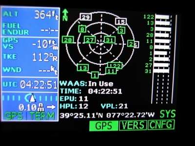
WAAS sensors receive the signal broadcast by Global Positioning
System (GPS) satellites, correct any errors, and rebroadcast the
corrected signals to WAAS-enabled aircraft receivers, thereby
enhancing the integrity, accuracy, reliability, and safety of the
already highly accurate GPS signal.
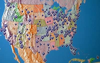
The WAAS signal that was turned on Thursday will give properly
equipped aircraft vertical guidance for some 500 published
procedures (LNAV/VNAV approaches) at more than 200 airports across
the United States. Typical LNAV/VNAV approaches allow pilots to
descend to 400 feet above the airport elevation in visibility down
to 1.5 miles.
Later this year, when tighter lateral and vertical navigation
(LPV) standards are implemented, pilots will be able to descend to
minima as low as 250 feet in 3/4-mile visibility. (The lowest
minima will require an obstruction-free environment near the
airport and ground infrastructure such as approach lights,
precision runway markings, and runway-parallel taxiways.)
Currently, two manufacturers of GA avionics — UPSAT and
Chelton — have WAAS-certified receivers that can be used for
"sole-source" IFR navigation, meaning no other navigation systems
are required on the aircraft. UPSAT expects to receive
certification for vertical navigation ("glideslope") within two
months. Other manufacturers will be offering WAAS receivers
soon.
For the near future, the "gold standard" for approach guidance
remains an instrument landing system (ILS). Ultimately though, in
perhaps a decade's time, WAAS has the potential to offer
ILS-quality information to pilots in a typical four-seat
single-engine GA aircraft.
AOPA LOVES WAAS
 "This is just the first
step," said AOPA President Phil Boyer during a press conference at
the FAA Command Center in Herndon, Virginia. "But in the future,
just try telling the family of a critically ill person who was
picked up by an air ambulance at a community airport in bad weather
that the expense and the time spent on developing WAAS was too
much."
"This is just the first
step," said AOPA President Phil Boyer during a press conference at
the FAA Command Center in Herndon, Virginia. "But in the future,
just try telling the family of a critically ill person who was
picked up by an air ambulance at a community airport in bad weather
that the expense and the time spent on developing WAAS was too
much."
AOPA has been a strong WAAS advocate since the program's
inception in 1995. The association has lobbied for WAAS in Congress
and was a key instigator of an independent review of the program in
2000 that determined WAAS was necessary and technically
feasible.
"Everywhere I go, GA pilots ask, 'How can we get an ILS at our
airport?" said Boyer. "WAAS is the answer for providing precision
approaches to all of those airports where ILS just isn't possible.
And we can provide an approach with vertical guidance to each
runway end."
"During the initial operational capability phase, there will
frequently be nonprecision approaches that have lower visibility
minimums than WAAS will," said Randy Kenagy, AOPA's senior director
of Advanced Technology. "But AOPA stands behind the FAA on the
deployment of WAAS. As it ramps up and proves itself, it will offer
advantages to pilots that will make them want to upgrade their
equipment."
"Now that there is a real, certified, and guaranteed signal in
space, the people who build the boxes will invest the research and
development into new WAAS receivers," Boyer said. "And the more
that enter the market, the better the prices will become."
"To borrow an analogy from the computer industry, the WAAS
initial operational capability phase is like version 1.0 software,"
said Kenagy. "It's neat, it's useful, and it will get better from
here."
But Boyer said it was still incumbent on FAA to spread the
benefits of the system so that it will be attractive for pilots to
buy WAAS boxes. "Now that FAA has turned on the signal, the agency
has to accelerate charting new approaches at those airports that
don't have them now," he said. "At the present rate, it will take
30 years to chart WAAS approaches into all airports. FAA must take
innovative steps such as turning to the private sector to survey
and design these approaches."
 ANN's Daily Aero-Linx (04.15.24)

