Collecting Information About Phytoplankton In The Atlantic Ocean
A team of researchers from NASA's Langley Research Center recently spent almost three weeks testing the waters — literally — from an airplane as part of a collaborative field campaign called Ship-Aircraft Bio-Optical Research, or SABOR.
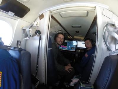
Flying aboard Langley's UC-12, the team, led by principal investigator Chris Hostetler, used an instrument called High Spectral Resolution Lidar, or HSRL-1, to collect data on the vertical distribution of phytoplankton in the Atlantic Ocean. The HSRL-1 fired a laser into the ocean to a depth of about 160 feet.
Phytoplankton, which are microscopic sea plants, are responsible for approximately half of the planet's photosynthetic activity, and they absorb a great deal of carbon dioxide in the process. They also form the foundation of the marine food chain. The timing and location of phytoplankton blooms can affect the migratory patterns of fish, thus impacting the business of commercial fisheries.
The SABOR campaign is an effort to advance space-based capabilities for monitoring these tiny living organisms in order to more clearly understand what they can tell researchers about marine ecology and the carbon cycle — the process through which carbon is exchanged on Earth.
Though the team from Langley has only just begun sifting through the waves of data, Hostetler said they're "delighted" with what they're seeing so far.
"The data set covers ocean regimes from the very turbid coastal ocean waters to the crystal clear blue waters of the Sargasso Sea," he said. "So it covers the entire dynamic range of what we want to investigate with lidar."
David Harper, an electronics engineer on Langley's SABOR team, was happy with how the HSRL-1 performed. It's been in use since 2006.
"The instrument performed very well and we were able to collect a high-fidelity and unique data set for the campaign," he said. "It's very rewarding to see the instrument operate so well for a full campaign after we've put so much effort into the design and build."
Complementing that HSRL-1 data are measurements taken by the Research Scanning Polarimeter, or RSP. The Langley team carried the RSP aboard the UC-12 to measure the way light scatters in the water and the air.
In addition, nearly 30,000 feet below, scientists aboard the National Science Foundation's Research Vessel Endeavor took ship-based measurements that will also help the Langley team validate and improve its data set.
The campaign covered an area that extended from the coastal waters of New England south to Bermuda, then west to the Virginia coast, then northeast back to New England. Plotted out on a map, the stretch of ocean is roughly triangular in shape.
As the Endeavor sliced through sometimes rough seas, the Langley team flew overhead, taking lidar measurements directly along the ship’s path. The UC-12 also flew crossing patterns over the research vessel in order to take polarimeter measurements. Hostetler estimates the campaign required nearly 100 hours in the air, making for a fairly intense three weeks.
The team maintained that intensity in part by rotating flight crews. That allowed them to have days where they flew three, even four, times.
"It was good — extremely productive," said Mike Wusk, a flight operations engineer on the campaign. "In my 30 years that I've been here, the sortie rate, the production of flights, was as high as anything I've seen."
And Hostetler believes all that operational intensity could have a significant payoff.
While scientists already know that phytoplankton store a great deal of carbon dioxide in the ocean, there's a lot of uncertainty about exactly how much and exactly what impact it's having on the carbon cycle. That uncertainty is due, in large part, to the lack of information on the vertical distribution of the phytoplankton.
The data collected by the HSRL-1 during the SABOR campaign could go a long way toward advancing our ability to acquire that information.
"It will be more quantitative than what anybody's done with lidar before," Hostetler said. "What's exciting to us about that is being able to demonstrate the application of this technique to a new problem to achieve the higher quantitative accuracy useful to the oceanographic community."
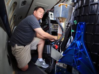
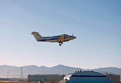
(Images provided by NASA. Top: NASA Langley team members Richard Hare, left, and David Harper aboard Langley's UC-12. The team used an instrument called High Spectral Resolution Lidar, or HSRL-1, to collect data on the vertical distribution of phytoplankton in the Atlantic Ocean. Center: David Harper, an electronics engineer on Langley's SABOR team, makes some final adjustments to the instruments prior to departing for the campaign. Bottom: NASA UC-12 (B-200) airplane)
 ANN's Daily Aero-Linx (04.15.24)

