'...Exhibited Significant Altitude Fluctuations Within A 30 Second Timespan'
Location: Williams, AZ Accident Number: WPR21LA166
Date & Time: April 15, 2021, 19:30 Local Registration: N2506N
Aircraft: Cessna 140 Injuries: 2 Fatal
Flight Conducted Under: Part 91: General aviation - Personal

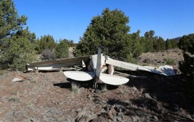
On April 15, 2021, about 1930 mountain standard time, a Cessna 140, N2506N, sustained substantial damage when it was involved in an accident in Williams, Arizona. The pilot and the passenger were fatally injured. The airplane was operated as a Title 14 Code of Federal Regulations (CFR) Part 91 personal flight.
According to the pilot’s social media postings, he had recently purchased the airplane. He and his passenger, who was also his spouse, departed Bermuda Dunes, California on April 12, with the planned destination of Sedona, Arizona. The exact itinerary could not be ascertained, but it is likely that on the accident flight they intended to land in Williams for the night and then land in Grand Canyon, Arizona the following day.
Recorded radar data covering the area of the accident was supplied by the Federal Aviation Administration (FAA) and was analyzed for time frame and proximity to the anticipated flight track of the airplane en route from Sedona to Williams. The radar data consisted of approximately equidistant radar returns from about 1855 to 1934. The data was consistent with the airplane departing Sedona and traveling about eight nautical miles (nm) west before turning north. The radar returns displayed a climb to about 10,000 feet mean sea level (msl) and continued on the north-northwest course for about 20 minutes. As the radar returns approach the proximity of Williams, the altitude had descended to 8,150 ft msl, equating to about 1,520 ft above ground level (agl).
As the radar returns approached the H. A. Clark Memorial Field Airport, the airplane made a right turn to the north consistent with the airplane making a 45° entry to adjoin the downwind leg for runway 18. The radar data was consistent with the airplane continuing on the base leg and exhibited significant altitude fluctuations within a 30 second timespan.
Between 1933:27 and 1933:37, the radar returns are consistent with the airplane transitioning from a northerly course to a west course and the speed decreasing from 82 kts to 60 kts while descending 525 ft. At 1933:51 the altitude increased 750 ft and the airspeed increased by 16 kts. At 1934:51, the last radar hit, located about 2,860 feet northeast of the accident site, showed a ground speed of 43 kts and an altitude of 570 ft agl.
The airplane impacted the ground about 1,430 ft east of the runway threshold. The left and right wings exhibited compression damage along the entirety of their leading edges. The wing flaps visually appeared to be in an extended position. The flap control linkage and cockpit flap-position indicator sustained damaged consistent with impact,
prohibiting investigators from being able to ascertain the position of the flaps at the time of impact.
Data from the United States Naval Observatory indicated that the phase of moon for the town of Williams was a waxing crescent with less than 25 percent of the moon’s disk illuminated.
Sunset occurred at 1902, with civil twilight ending at 1928. The moon rise occurred at 0838 and moon set at 2333; at the time of the accident the moon was about 31° below the horizon (including refraction) on an azimuth (heading) of 343°.
The airport was located just north of the city of Williams; both were situated in a wide valley surrounded by mountainous terrain. The area surrounding the airport and the city was primarily desert with very sparse illumination. A review of the airport facility directory revealed that airport elevation was 6,630 feet msl and the runway was 100 feet wide by 6,000 feet in length. The airport operated a lighted white-green beacon that was operational from sunset to sunrise. The airport was equipped with a precision approach path indicator light system designed to provide safe obstruction clearance. Pilot-activated medium intensity runway lights illuminated runway 18, and runway end identifier lights were installed.
 SpaceX to Launch Inversion RAY Reentry Vehicle in Fall

