Solar Ultraviolet Imager Ready To Fly On NOAA Satellite | Aero-News Network
Aero-News Network
RSS icon RSS feed
podcast icon MP3 podcast
Subscribe Aero-News e-mail Newsletter Subscribe

Airborne Unlimited -- Most Recent Daily Episodes

Episode Date

Airborne-Monday

Airborne-Tuesday

Airborne-Wednesday Airborne-Thursday

Airborne-Friday

Airborne On YouTube

Airborne-Unlimited-04.01.24

Airborne-Unlimited-04.16.24

Airborne-FlightTraining-04.17.24 Airborne-Unlimited-04.11.24

Airborne-Unlimited-04.12.24

Join Us At 0900ET, Friday, 4/10, for the LIVE Morning Brief.
Watch It LIVE at
www.airborne-live.net

Mon, Dec 23, 2013

Solar Ultraviolet Imager Ready To Fly On NOAA Satellite

Lockheed Martin To Deliver The Instrument In January

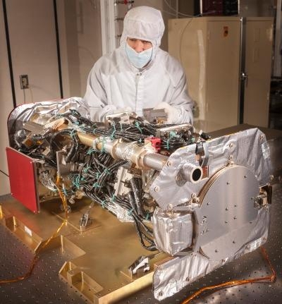
A Lockheed Martin team has completed the Solar Ultraviolet Imager (SUVI) instrument that will make crucial solar measurements when it flies on the National Oceanic and Atmospheric Administration's (NOAA) next-generation Geostationary Operational Environmental Satellite (GOES) satellite missions, known as the GOES-R series.

The team is on track for instrument delivery in January 2014 for integration with the first GOES-R spacecraft at Lockheed Martin's Space Systems facility in Denver. The advanced spacecraft and instrument technology used on the GOES-R series is expected to improve the quality and timeliness of forecasts, expanding the safety and economic benefits to the public.

"We are enormously pleased to have reached this milestone with our first SUVI flight unit," said Mons Morrison, Lockheed Martin SUVI program manager at the Advanced Technology Center (ATC) in Palo Alto. "We look forward to continuing our collaboration with NASA and NOAA to produce the best possible instrument – and to work side by side with our Lockheed Martin Civil Space colleagues who are designing and building the GOES-R spacecraft."

The SUVI will provide the required solar observational capabilities that enable NOAA's Space Weather Prediction Center in Boulder, CO. to monitor solar activity and to issue accurate, real-time alerts when space weather may possibly affect the performance and reliability of space-borne and ground-based technological systems. Space weather can disrupt satellite operations, communications, navigation, and the distribution of electricity through power grids. These can lead to economic losses and can potentially endanger human life.

Operational since 1975, the GOES program is operated by NOAA's National Environmental Satellite, Data, and Information Service (NESDIS) and is a critical part of the U.S. satellite constellation for environmental observations. The GOES satellites are a key element in NOAA's National Weather Service (NWS) operations, providing a continuous stream of environmental information (weather imagery and sounding data) used to support weather forecasting, severe-storm tracking, and meteorological research. Along with weather forecasting, the GOES program also provides data to support space weather forecasting, public safety, and scientific researchers use the data to better understand land, atmosphere, ocean, and climate interactions.

(Image provided by Lockheed Martin)

FMI: www.lochkeedmartin.com

Advertisement

More News

ANN's Daily Aero-Linx (04.15.24)

Aero Linx: International Flying Farmers IFF is a not-for-profit organization started in 1944 by farmers who were also private pilots. We have members all across the United States a>[...]

Classic Aero-TV: 'No Other Options' -- The Israeli Air Force's Danny Shapira

From 2017 (YouTube Version): Remembrances Of An Israeli Air Force Test Pilot Early in 2016, ANN contributor Maxine Scheer traveled to Israel, where she had the opportunity to sit d>[...]

Aero-News: Quote of the Day (04.15.24)

"We renegotiated what our debt restructuring is on a lot of our debts, mostly with the family. Those debts are going to be converted into equity..." Source: Excerpts from a short v>[...]

Airborne 04.16.24: RV Update, Affordable Flying Expo, Diamond Lil

Also: B-29 Superfortress Reunion, FAA Wants Controllers, Spirit Airlines Pulls Back, Gogo Galileo Van's Aircraft posted a short video recapping the goings-on around their reorganiz>[...]

ANN's Daily Aero-Term (04.16.24): Chart Supplement US

Chart Supplement US A flight information publication designed for use with appropriate IFR or VFR charts which contains data on all airports, seaplane bases, and heliports open to >[...]

blog comments powered by Disqus


Advertisement

Advertisement

Podcasts

Advertisement

© 2007 - 2024 Web Development & Design by Pauli Systems, LC