Two Incidents In Recent Years Prompted The Safety Recommendations
The NTSB has issued two safety recommendations dealing with ways to prevent wrong-airport landings.
The board recommended to the FAA that the agency mend air traffic control procedures so that controllers withhold landing clearance until the aircraft has passed all other airports that may be confused with the destination airport. (A-15-009), and modify the minimum safe altitude warning (MSAW) software to apply the MSAW parameters for the flight plan destination airport to touchdown, rather than automatically reassigning the flight to another airport based on an observed (and possibly incorrect) trajectory. (A-15-010).
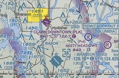
On January 12, 2014, about 1810 central standard time,Southwest Airlines flight 4013, Boeing 737-7H4, N272WN, mistakenly landed at M. Graham Clark Downtown Airport (PLK), Branson, Missouri, which was 6 miles (mi) north of the intended destination of Branson Airport (BBG), Branson, Missouri. The flight had been cleared to land on runway 14 at BBG, which was 7,140 ft long. Instead, the flight landed on runway 12 at PLK, which was 3,738 ft long. There were no injuries to the 124 passengers and 7 crewmembers, and the airplane was not damaged.
The airplane was being operated under the provisions of 14 Code of Federal Regulations (CFR) Part 121 as a regularly scheduled passenger flight from Chicago Midway International Airport (MDW), Chicago, Illinois. Night visual meteorological conditions (VMC) prevailed at the time. Southwest Airlines flight 4013 departed MDW for a regularly scheduled flight to BBG about 1654. The flight crew contacted the terminal radar approach control facility at Springfield-Branson National Airport (SGF), Springfield, Missouri, about 1752 when the airplane was about 60 nautical mi northeast of BBG and descending from 18,000 ft to 16,000 ft.
At 1802:50, the SGF approach controller advised the pilot that “the airport” was at his 11 o’clock position and 15 mi. Radar data indicated that the airport at the airplane’s 11 o’clock at 15 mi was actually PLK, not the destination airport of BBG. (BBG was at the airplane’s 10 o’clock and was about 20 mi from the airplane.)
At 1802:58, the pilot reported “field in sight.” The SGF approach controller cleared the pilot for the visual approach to runway 14 at BBG, advised that radar services were terminated, and directed the pilot to contact the Branson tower; the pilot acknowledged the instruction. At 1803:15, the pilot checked in with the BBG tower, reporting out of 6,600 ft descending to 3,000 ft and going direct to the final approach fix for the visual approach to runway 14. The BBG controller issued Southwest Airlines flight 4013 a landing clearance for runway 14, which was 7,140 ft long. However, the airplane touched down on runway 12 at PLK, which was only 3,738 ft long. Visible tire marks indicated that the airplane stopped 3,109 ft from the displaced approach threshold.
PLK and BBG were both located below SGF radar coverage. According to SGF controller interviews, radar coverage ceased and radar contact was lost for aircraft arriving at BBG between 2,200 and 2,600 ft. Accordingly, there were no MSAW alerts associated with this event.

In the other event, On November 21, 2013, about 2120, Atlas Air flight 4241, a Boeing 747-400LCF (Dreamlifter), N780BA, registered to Boeing Aircraft Holding Company, mistakenly landed at Colonel James Jabara Airport (AAO), Wichita, Kansas, instead of its intended destination of McConnell Air Force Base (IAB), Wichita, Kansas.
VMC prevailed, and an instrument flight rules (IFR) flight plan was filed. There were no injuries to the two flight crewmembers, and the airplane was not damaged. The airplane was being operated under the provisions of 14 CFR Part 121 as a domestic cargo flight from John F. Kennedy International Airport, New York, New York, to IAB.4 The pilot of Atlas Air flight 4241 contacted approach control at Wichita Mid-Continent Airport (ICT), Wichita, Kansas, at 2110:50, reporting that the airplane was leveling at 10,000 ft.
The ICT approach controller responded that the pilot should expect vectors to the tactical air navigation approach for runway 19L at IAB unless the pilot preferred the visual approach. At 2111:10, the pilot replied that he preferred the area navigation (RNAV) approach to runway 19L; the ICT approach controller cleared the pilot for the RNAV approach to runway 19L. At 2114:00, the ICT approach controller transmitted, “…4241 heavy, you’re 25 miles from the airport, cross WITBA at 4,000, cleared RNAV/GPS runway 19L approach.” At 2118:45, with the airplane at 3,900 ft, 12 mi north of IAB and 4.6 mi north of AAO, the controller instructed the pilot to contact the IAB tower.
At 2118:54, the pilot contacted the IAB tower and stated, “on the vis or uh GPS, RNAV GPS approach at runway 1 9 left.” At 2119:05, the IAB tower controller cleared the airplane to land on runway 19L, which was about 12,000 ft long. However, at 2120:38, the airplane touched down on the runway at AAO, which was only about 6,100 ft long. During the 25 minutes after landing, several other operations occurred at AAO while the 747 was on the runway, further negatively impacting flight safety.
The NTSB is also aware of the several other wrong airport landing events involving both civil and military aircraft.
In the letter dated May 4, the NTSB urged the FAA to take action on the safety recommendations addressing the issuance of landing clearances with multiple airports in the vicinity and minimum safe altitude warning (MSAW) software limitations. The recommendations are derived from its investigations of wrong airport landing events.
(Dreamlifter pictured in file photo)
 ANN's Daily Aero-Linx (04.13.24)

