Thales, Aerovision Present Frontex With UAV For Border Control | Aero-News Network
Aero-News Network
RSS icon RSS feed
podcast icon MP3 podcast
Subscribe Aero-News e-mail Newsletter Subscribe

Airborne Unlimited -- Most Recent Daily Episodes

Episode Date

Airborne-Monday

Airborne-Tuesday

Airborne-Wednesday Airborne-Thursday

Airborne-Friday

Airborne On YouTube

Airborne-Unlimited-04.01.24

Airborne-Unlimited-04.16.24

Airborne-FlightTraining-04.17.24 Airborne-Unlimited-04.11.24

Airborne-Unlimited-04.12.24

Join Us At 0900ET, Friday, 4/10, for the LIVE Morning Brief.
Watch It LIVE at
www.airborne-live.net

Thu, Jan 19, 2012

Thales, Aerovision Present Frontex With UAV For Border Control

Fulmar UAV Was The Only Fully Spanish Model Presented To The European Agency For Border Control Purposes

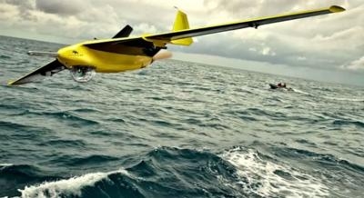
Thales and Aerovisión have given a real flight demonstration of the Fulmar UAV for the European Agency Frontex, which is charged with coordinating the border control operations of the European Union member states.

Fulmar is a wholly Spanish project that is a global solution that uses the Maritime Surveillance Systems of Thales Group. These systems supply images and video in real time and integrate the information in a security system, as is the case with border control. Such systems facilitate surveillance and control of maritime and border traffic and can provide inestimable support to rescue operations.
 
The Fulmar UAV is a small-size model weighing only 41 pounds that can fly at a height of 10,000 feet and achieve 80 knots, with an 8-hour flight range that would allow it to fly nearly 500 miles without having to refuel.
 
The demonstration for border authorities organized by Frontex was held at the Aktio Air Base in the Greek locality of Preveza. For three days, several international UAV manufacturers performed test flights patrolling the west coast of Greece, with Fulmar being the only Spanish product to demonstrate its capacities in a market dominated by unmanned aerial vehicles from the United States and Israel.
 
The demonstration confirmed the ease of installation and flying of the UAV, as it does not require a runway for takeoff and landing. It is launched from a catapult and is recovered by means of an impact-absorbing net. Both elements are simple to install in a short time and in different places. This facilitates the assembly and handling of the system and differentiates it from other models on the market.

In the demonstration for border authorities organized by Frontex, the Fulmar flew for two hours, detecting the information sent in from the different points established for the flight and sending images and video in real time that were viewed by the attendants at the ground base. The aircraft displayed its capacity to integrate with maritime surveillance systems such as radars, a crucial aspect in this type of unmanned aerial surveillance system. (Image provided by Aerovision)

FMI: www.aerovision-uav.com

Advertisement

More News

ANN's Daily Aero-Linx (04.15.24)

Aero Linx: International Flying Farmers IFF is a not-for-profit organization started in 1944 by farmers who were also private pilots. We have members all across the United States a>[...]

Classic Aero-TV: 'No Other Options' -- The Israeli Air Force's Danny Shapira

From 2017 (YouTube Version): Remembrances Of An Israeli Air Force Test Pilot Early in 2016, ANN contributor Maxine Scheer traveled to Israel, where she had the opportunity to sit d>[...]

Aero-News: Quote of the Day (04.15.24)

"We renegotiated what our debt restructuring is on a lot of our debts, mostly with the family. Those debts are going to be converted into equity..." Source: Excerpts from a short v>[...]

Airborne 04.16.24: RV Update, Affordable Flying Expo, Diamond Lil

Also: B-29 Superfortress Reunion, FAA Wants Controllers, Spirit Airlines Pulls Back, Gogo Galileo Van's Aircraft posted a short video recapping the goings-on around their reorganiz>[...]

ANN's Daily Aero-Term (04.16.24): Chart Supplement US

Chart Supplement US A flight information publication designed for use with appropriate IFR or VFR charts which contains data on all airports, seaplane bases, and heliports open to >[...]

blog comments powered by Disqus


Advertisement

Advertisement

Podcasts

Advertisement

© 2007 - 2024 Web Development & Design by Pauli Systems, LC