AL TFR: 02.06.06 | Aero-News Network
Aero-News Network
RSS icon RSS feed
podcast icon MP3 podcast
Subscribe Aero-News e-mail Newsletter Subscribe

Airborne Unlimited -- Most Recent Daily Episodes

Episode Date

Airborne-Monday

Airborne-Tuesday

Airborne-Wednesday Airborne-Thursday

Airborne-Friday

Airborne On YouTube

Airborne-Unlimited-04.01.24

Airborne-Unlimited-04.09.24

Airborne-Unlimited-04.10.24 Airborne-Unlimited-04.11.24

Airborne-Unlimited-04.12.24

Join Us At 0900ET, Friday, 4/10, for the LIVE Morning Brief.
Watch It LIVE at
www.airborne-live.net

Fri, Feb 03, 2006

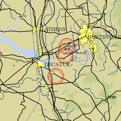
AL TFR: 02.06.06

NOTAM Number: FDC 6/1394 
Issue Date: February 03, 2006 at 14:44 UTC
Location: Huntsville, Alabama
Beginning Date and Time: February 06, 2006 at 16:30 UTC
Ending Date and Time: February 06, 2006 at 21:05 UTC
Reason for NOTAM: Temporary flight restrictions for VIP (Very Important Person) Movement
Type: VIP
Replaced NOTAM(s): N/A

Affected Area(s) 

Area A 
 Airspace Definition: 
 TFR Center: 8.3 nautical miles from DECATUR VOR/DME(DCU) on the 100 radial (Latitude: 34�37'37"N, Longitude: 86�46'22"W)
 Radius: 3 nautical miles
 Altitude: From the surface up to but not including 3000 feet AGL 
 Effective Date(s): 
 February 06, 2006 at 16:30 UTC (February 06, 2006 at 10:30 CST) - February 06, 2006 at 17:20 UTC (February 06, 2006 at 11:20 CST)

Area B 
 Airspace Definition: 
 TFR Center: 9.5 nautical miles from DECATUR VOR/DME(DCU) on the 157 radial (Latitude: 34�30'12"N, Longitude: 86�51'38"W)
 Radius: 3 nautical miles
 Altitude: From the surface up to but not including 3000 feet AGL 
 Effective Date(s): 
 February 06, 2006 at 17:05 UTC (February 06, 2006 at 11:05 CST) - February 06, 2006 at 19:15 UTC (February 06, 2006 at 13:15 CST)

Area C 
 Airspace Definition: 
 TFR Center: 9 nautical miles from ROCKET VORTAC(RQZ) on the 218 radial (Latitude: 34�40'57"N, Longitude: 86�45'06"W)
 Radius: 3 nautical miles
 Altitude: From the surface up to but not including 3000 feet AGL 
 Effective Date(s): 
 February 06, 2006 at 18:55 UTC (February 06, 2006 at 12:55 CST) - February 06, 2006 at 20:50 UTC (February 06, 2006 at 14:50 CST)

Area D 
 Airspace Definition: 
 TFR Center: 8.3 nautical miles from DECATUR VOR/DME(DCU) on the 100 radial (Latitude: 34�37'37"N, Longitude: 86�46'22"W)
 Radius: 3 nautical miles
 Altitude: From the surface up to but not including 3000 feet AGL 
 Effective Date(s): 
 February 06, 2006 at 20:15 UTC (February 06, 2006 at 14:15 CST) - February 06, 2006 at 21:05 UTC (February 06, 2006 at 15:05 CST)

Operating Restrictions and Requirements 

No pilots may operate an aircraft in the areas covered by this NOTAM (except as described).

 Unless otherwise authorized by the ATC.

Other Information:

ARTCC: ZME - Memphis Center
Authority: Title 14 CFR section 91.141

FMI: www.tfr.faa.gov, Depicted TFR data may not be a complete listing. Pilots should not use the information on this website for flight planning purposes. For the latest information, call your local Flight Service Station at 1-800-WX-BRIEF.

Advertisement

More News

ANN's Daily Aero-Linx (04.13.24)

Aero Linx: Florida Antique Biplane Association "Biplanes.....outrageous fun since 1903." That quote really defines what the Florida Antique Biplane Association (FABA) is all about.>[...]

ANN's Daily Aero-Term (04.13.24): Beyond Visual Line Of Sight (BVLOS)

Beyond Visual Line Of Sight (BVLOS) The operation of a UAS beyond the visual capability of the flight crew members (i.e., remote pilot in command [RPIC], the person manipulating th>[...]

Airborne 04.09.24: SnF24!, Piper-DeltaHawk!, Fisher Update, Junkers

Also: ForeFlight Upgrades, Cicare USA, Vittorazi Engines, EarthX We have a number of late-breaking news highlights from the 2024 Innovation Preview... which was PACKED with real ne>[...]

Aero-News: Quote of the Day (04.14.24)

“For Montaer Aircraft it is a very prudent move to incorporate such reliable institution as Ocala Aviation, with the background of decades in training experience and aviation>[...]

ANN's Daily Aero-Term (04.14.24): Maximum Authorized Altitude

Maximum Authorized Altitude A published altitude representing the maximum usable altitude or flight level for an airspace structure or route segment. It is the highest altitude on >[...]

blog comments powered by Disqus


Advertisement

Advertisement

Podcasts

Advertisement

© 2007 - 2024 Web Development & Design by Pauli Systems, LC