US Navy Detects 'Black Box' From Missing Adam Air 737 | Aero-News Network
Aero-News Network
RSS icon RSS feed
podcast icon MP3 podcast
Subscribe Aero-News e-mail Newsletter Subscribe

Airborne Unlimited -- Most Recent Daily Episodes

Episode Date

Airborne-Monday

Airborne-Tuesday

Airborne-Wednesday Airborne-Thursday

Airborne-Friday

Airborne On YouTube

Airborne-Unlimited-04.01.24

Airborne-Unlimited-04.09.24

Airborne-Unlimited-04.10.24 Airborne-Unlimited-04.11.24

Airborne-Unlimited-04.12.24

Join Us At 0900ET, Friday, 4/10, for the LIVE Morning Brief.
Watch It LIVE at
www.airborne-live.net

Thu, Jan 25, 2007

US Navy Detects 'Black Box' From Missing Adam Air 737

Ship's Crew Finds Debris Scattered Over Wide Area

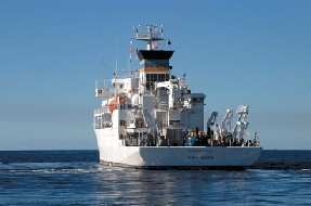
The USNS Mary Sears, searching off the western coast of Sulawesi island, has detected what the US Navy believes to be signals from the cockpit voice and flight data recorders of Adam Air flight 574. The aircraft went missing with 102 people aboard on New Year's Day enroute to Manado in northern Sulawesi from Surabaya in East Java.

"During the search of the projected crash site of Adam Air Flight 574, the Mary Sears, using a Towed Pinger Locator, detected pingers on the same frequency of the black box associated with the missing airplane," the US embassy said in a prepared statement.

The USNS Mary Sears is one of several specialized oceanographic research ships operated by the Naval Meteorology and Oceanography Command of the US Navy.

Pieces of wreckage from the 737-400 have turned up over the past weeks in the area where the Mary Sears' crew detected the signals, but so far none have provided clues to determine what happened to the jet.

A Singaporean team searched for the Boeing's recorders, but gave up and returned home earlier this week. Investigators hope finding the black box will lead to finding major portions of the aircraft and an understanding of its fate.

US Navy officials say the USNS Mary Sears has found "heavy debris" scattered over a wide area near where the signals were detected, and is analyzing the data.

The US Embassy said it's passed all the information to Indonesian authorities and the USNS Mary Sears will be leaving the area on Friday.

Indonesia's search and rescue agency said its efforts to locate the downed jet were hampered by the depth of the ocean in the area, known as the Makassar Strait.

Flight recorders are capable of transmitting a locator signal for up to 30 days to help searchers find them, but the water in the Makassar Strait can be deep as 6,000 feet.

FMI: www.navy.mil, www.adamair.co.id

Advertisement

More News

ANN's Daily Aero-Linx (04.13.24)

Aero Linx: Florida Antique Biplane Association "Biplanes.....outrageous fun since 1903." That quote really defines what the Florida Antique Biplane Association (FABA) is all about.>[...]

ANN's Daily Aero-Term (04.13.24): Beyond Visual Line Of Sight (BVLOS)

Beyond Visual Line Of Sight (BVLOS) The operation of a UAS beyond the visual capability of the flight crew members (i.e., remote pilot in command [RPIC], the person manipulating th>[...]

Airborne 04.09.24: SnF24!, Piper-DeltaHawk!, Fisher Update, Junkers

Also: ForeFlight Upgrades, Cicare USA, Vittorazi Engines, EarthX We have a number of late-breaking news highlights from the 2024 Innovation Preview... which was PACKED with real ne>[...]

Aero-News: Quote of the Day (04.14.24)

“For Montaer Aircraft it is a very prudent move to incorporate such reliable institution as Ocala Aviation, with the background of decades in training experience and aviation>[...]

ANN's Daily Aero-Term (04.14.24): Maximum Authorized Altitude

Maximum Authorized Altitude A published altitude representing the maximum usable altitude or flight level for an airspace structure or route segment. It is the highest altitude on >[...]

blog comments powered by Disqus


Advertisement

Advertisement

Podcasts

Advertisement

© 2007 - 2024 Web Development & Design by Pauli Systems, LC