Sun, Feb 05, 2012
GRAIL Satellites Return Unique Images To Earth
A camera aboard one of NASA's twin Gravity Recovery And Interior
Laboratory (GRAIL) lunar spacecraft has returned its first unique
view of the far side of the moon. MoonKAM, or Moon Knowledge
Acquired by Middle school students, will be used by students
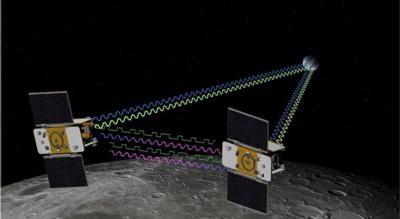
nationwide to select lunar images for study. GRAIL consists of two
identical spacecraft, recently named Ebb and Flow, each of which is
equipped with a MoonKAM. The images were taken as part of a test of
Ebb's MoonKAM on Jan. 19. The GRAIL project plans to test the
MoonKAM aboard Flow at a later date.
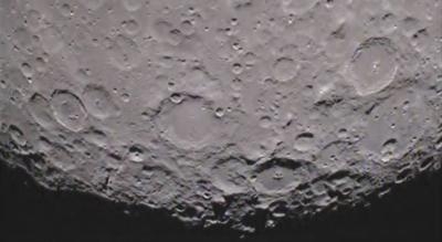
In the video, (which should have a Pink Floyd soundtrack, don't
you think?) the north pole of the moon is visible at the top of the
screen as the spacecraft flies toward the lunar south pole. One of
the first prominent geological features seen on the lower third of
the moon is the Mare Orientale, a 560-mile-wide (900 kilometer)
impact basin that straddles both the moon's near and far side. The
clip ends with rugged terrain just short of the lunar south pole.
To the left of center, near the bottom of the screen, is the
93-mile-wide (149 kilometer) Drygalski crater with a distinctive
star-shaped formation in the middle. The formation is a central
peak, created many billions of years ago by a comet or asteroid
impact. The quality of the video is excellent and should energize
our MoonKAM students as they prepare to explore the moon," said
Maria Zuber, GRAIL principal investigator from the Massachusetts
Institute of Technology in Cambridge.
The twin spacecraft successfully achieved lunar orbit this past
New Year's Eve and New Year's Day. Previously named GRAIL-A and
GRAIL-B, the washing machine-sized spacecraft received their new
names from fourth graders at the Emily Dickinson Elementary School
in Bozeman, Mont., following a nationwide student naming contest.
Thousands of fourth- to eighth-grade students will select target
areas on the lunar surface and send requests to the GRAIL MoonKAM
Mission Operations Center in San Diego. Photos of the target areas
will be sent back by the satellites for students to study. The
MoonKAM program is led by Sally Ride, America's first woman in
space. Her team at Sally Ride Science and undergraduate students at
the University of California in San Diego will engage middle
schools across the country in the GRAIL mission and lunar
exploration. GRAIL is NASA's first planetary mission carrying
instruments fully dedicated to education and public outreach.
"We have had great response from schools around the country;
more than 2,500 signed up to participate so far," Ride said. "In
mid-March, the first pictures of the moon will be taken by students
using MoonKAM. I expect this will excite many students about
possible careers in science and engineering."
Launched in September 2011, Ebb and Flow periodically perform
trajectory correction maneuvers that, over time, will lower their
orbits to near-circular ones with an altitude of about 34 miles (55
kilometers). During their science mission, the duo will answer
longstanding questions about the moon and give scientists a better
understanding of how Earth and other rocky planets in the solar
system formed. (Images provided by NASA)
More News
Aero Linx: International Flying Farmers IFF is a not-for-profit organization started in 1944 by farmers who were also private pilots. We have members all across the United States a>[...]
From 2017 (YouTube Version): Remembrances Of An Israeli Air Force Test Pilot Early in 2016, ANN contributor Maxine Scheer traveled to Israel, where she had the opportunity to sit d>[...]
"We renegotiated what our debt restructuring is on a lot of our debts, mostly with the family. Those debts are going to be converted into equity..." Source: Excerpts from a short v>[...]
Also: B-29 Superfortress Reunion, FAA Wants Controllers, Spirit Airlines Pulls Back, Gogo Galileo Van's Aircraft posted a short video recapping the goings-on around their reorganiz>[...]
Chart Supplement US A flight information publication designed for use with appropriate IFR or VFR charts which contains data on all airports, seaplane bases, and heliports open to >[...]
 ANN's Daily Aero-Linx (04.15.24)

