Garmin Pilot Expands Coverage Into Canada | Aero-News Network
Aero-News Network
RSS icon RSS feed
podcast icon MP3 podcast
Subscribe Aero-News e-mail Newsletter Subscribe

Airborne Unlimited -- Most Recent Daily Episodes

Episode Date

Airborne-Monday

Airborne-Tuesday

Airborne-Wednesday Airborne-Thursday

Airborne-Friday

Airborne On YouTube

Airborne-Unlimited-04.22.24

Airborne-Unlimited-04.16.24

Airborne-FlightTraining-04.17.24 Airborne-AffordableFlyers-04.18.24

Airborne-Unlimited-04.19.24

Join Us At 0900ET, Friday, 4/10, for the LIVE Morning Brief.
Watch It LIVE at
www.airborne-live.net

Sat, Aug 23, 2014

Garmin Pilot Expands Coverage Into Canada

App Available Now In The iTunes Store

Just last month, Garmin Pilot announced worldwide coverage for iPad and iPhone so pilots around the globe can access all of the exciting features Garmin Pilot has to offer. These features included flight planning capabilities, comprehensive weather coverage and feature-rich navigation. With a lot of momentum behind us, Garmin is continuing to add even more coverage for pilots around the world ... this time, in Canada.

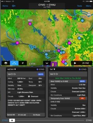
Garmin Pilot Canada Premium is available now in the iTunes store and offers a comprehensive suite of navigation and weather information for both Canada and the United States. North American navigation data provided by Jeppesen, ensures pilots have the information they need for flight planning. Rich, interactive maps within Garmin Pilot support north-up and track-up navigation, so maps, their labels and the information displayed on the map is upright and easy to read. Geo-referenced FliteCharts include approaches, departures and arrival procedures and SafeTaxi incorporates geo-referenced airport diagrams in Canada.

Because weather information is an important part of flight planning for every pilot, radar and satellite imagery for Canada and the United States is available with the latest update. Since precipitation and cloud cover information can be displayed on the moving map alongside flight plan information, it’s easy to determine if weather will impact your route of flight. METARs, TAFs, AIRMETs, SIGMETs, NOTAMs and winds aloft information provide pilots with even more weather data, which can also be overlaid on top of the moving map or viewed in split-screen mode.

Situational awareness is enhanced with Garmin Pilot, which offers obstacle and terrain alerting capabilities similar to our portable and panel mount avionics. Terrain information may be viewed on the dedicated terrain page or as an overlay on the moving map and pop-up alerts also offer an additional layer of protection to warn of nearby obstacles or terrain. Synthetic vision (SVX) adds to the feature-rich capabilities of Garmin Pilot Canada Premium, offering a 3D depiction of ground, water, obstacles, terrain and the runway environment so it’s easier than ever to navigate in terrain-challenging environments.

Garmin Pilot Canada Premium is available immediately in the iTunes store for $129.99 annually and includes comprehensive navigation information, radar and satellite imagery, FliteCharts and SafeTaxi for the U.S. and Canada.

(Image provided with Garmin news release)

FMI: www.garmin.com

Advertisement

More News

ANN's Daily Aero-Term (04.20.24): Light Gun

Light Gun A handheld directional light signaling device which emits a brilliant narrow beam of white, green, or red light as selected by the tower controller. The color and type of>[...]

Aero-News: Quote of the Day (04.20.24)

"The journey to this achievement started nearly a decade ago when a freshly commissioned Gentry, driven by a fascination with new technologies and a desire to contribute significan>[...]

ANN's Daily Aero-Linx (04.21.24)

Aero Linx: JAARS, Inc. For decades now, we’ve landed planes on narrow rivers and towering mountains. We’ve outfitted boats and vehicles to reach villages that rarely se>[...]

Aero-News: Quote of the Day (04.21.24)

"Our driven and innovative team of military and civilian Airmen delivers combat power daily, ensuring our nation is ready today and tomorrow." Source: General Duke Richardson, AFMC>[...]

ANN's Daily Aero-Term (04.21.24): Aircraft Conflict

Aircraft Conflict Predicted conflict, within EDST of two aircraft, or between aircraft and airspace. A Red alert is used for conflicts when the predicted minimum separation is 5 na>[...]

blog comments powered by Disqus


Advertisement

Advertisement

Podcasts

Advertisement

© 2007 - 2024 Web Development & Design by Pauli Systems, LC