Landsat Launch Continues 40-Year Legacy
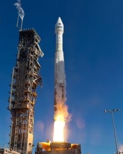
NASA's Landsat Data Continuity Mission (LDCM) roared into space at 1302 EST Monday aboard an Atlas V rocket from Vandenberg Air Force Base in California. The LDCM spacecraft separated from the rocket 79 minutes after launch and the first signal was received 3 minutes later at a ground station in Svalbard, Norway. The solar arrays deployed 86 minutes after launch, and the spacecraft is generating power from them. LDCM is on course to reach its operational, sun-synchronous, polar orbit 438 miles above Earth within two months.
"Landsat is a centerpiece of NASA's Earth Science program, and today's successful launch will extend the longest continuous data record of Earth's surface as seen from space," NASA Administrator Charles Bolden said. "This data is a key tool for monitoring climate change and has led to the improvement of human and biodiversity health, energy and water management, urban planning, disaster recovery and agriculture monitoring -- all resulting in incalculable benefits to the U.S. and world economy."
LDCM will go through a check-out phase for the next three months. Afterward, operational control will be transferred to NASA's mission partner, the Department of the Interior's U.S. Geological Survey (USGS), and the satellite will be renamed Landsat 8. Data will be archived and distributed free over the Internet from the Earth Resources and Science (EROS) center in Sioux Falls, S.D. Distribution of Landsat 8 data from the USGS archive is expected to begin within 100 days of launch.
LDCM is the eighth in the Landsat series of satellites that have been continuously observing Earth's land surfaces since 1972. "Landsat has been delivering invaluable scientific information about our planet for more than forty years," Interior Secretary Ken Salazar said. "It's an honor to be a part of today's launch to ensure this critical data will continue to help us better understand our natural resources and help people like water managers, farmers, and resource managers make informed decisions."
The use of Landsat data been transformed in recent years by advancements in computing power and the decision by USGS to allow free online access to the information. This revolution has allowed scientists to detect changes over time to our planet and has enabled a host of applications based on Landsat measurements to be developed by researchers, the private sector, and state, local, and tribal governments.
LDCM continues that legacy with more and better observations. The spacecraft carries two instruments, the Operational Land Imager (OLI) and Thermal Infrared Sensor (TIRS). The measurements will be compatible with data from past Landsat satellites, but the LDCM instruments use advanced technology to improve reliability, sensitivity, and data quality. "LDCM is the best Landsat satellite ever built," said Jim Irons, a LDCM project scientist at NASA's Goddard Space Flight Center in Greenbelt, Md. "The technology will advance and improve the array of scientific investigations and resource management applications supported by Landsat images. I anticipate new knowledge and applications to emerge with an increasing demand for the data."
OLI will continue observations currently made by Landsat 7 in the visible, near infrared, and shortwave infrared portions of the electromagnetic spectrum. It also will take measurements in two new bands, one to observe high-altitude cirrus clouds and another to observe atmospheric aerosols as well as water quality in lakes and shallow coastal waters. OLI's new design has fewer moving parts than instruments on previous Landsat satellites.
TIRS will collect data on heat emitted from Earth's surface in two thermal bands, as compared with a single thermal band on previous Landsat satellites. These thermal band observations are becoming increasingly vital to monitoring water consumption, especially in the arid western United States.
(Image provided by United Launch Alliance)
 Classic Aero-TV: The Switchblade Flying Car FLIES!

