DJI, AirMap Deliver Real-Time Wildfire Awareness And Geofencing Capabilities | Aero-News Network
Aero-News Network
RSS icon RSS feed
podcast icon MP3 podcast
Subscribe Aero-News e-mail Newsletter Subscribe

Airborne Unlimited -- Most Recent Daily Episodes

Episode Date

Airborne-Monday

Airborne-Tuesday

Airborne-Wednesday Airborne-Thursday

Airborne-Friday

Airborne On YouTube

Airborne-Unlimited-04.01.24

Airborne-Unlimited-04.16.24

Airborne-FlightTraining-04.17.24 Airborne-Unlimited-04.11.24

Airborne-Unlimited-04.12.24

Join Us At 0900ET, Friday, 4/10, for the LIVE Morning Brief.
Watch It LIVE at
www.airborne-live.net

Thu, Jul 21, 2016

DJI, AirMap Deliver Real-Time Wildfire Awareness And Geofencing Capabilities

Reliable, Real-Time Awareness Of Wildfires Reduces Drone Interference For Operators And Firefighters

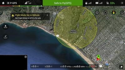
DJI and AirMap have added real-time wildfire alerts to their geofencing data to help keep unauthorized drones from interfering with firefighting operations.

AirMap now obtains wildfire information directly from the U.S. Department of the Interior's incident command system and immediately pushes it to drone pilots through AirMap's iOS and web apps, AirMap's API, and the GEO geofencing system included in the DJI GO flight control app. This data is more current and includes more active wildfires than Temporary Flight Restrictions (TFRs) published by the Federal Aviation Administration (FAA).

"AirMap delivers dynamic airspace intelligence to unmanned aircraft in order to provide the safest operating environment possible," said Ben Marcus, CEO of AirMap. "Through our partnership with DJI and other drone manufacturers and application developers, more than 70 percent of the drones operated in the United States now benefit from wildfire information in real time."

"DJI wants to equip its customers with safety-critical information that will help our first responders, whether or not a TFR has been issued," said Brendan Schulman, DJI Vice President of Policy and Legal Affairs. "This enhancement to GEO will help prevent DJI drones from inadvertently taking off within, or flying into, a wildfire location without authorization."

Unauthorized drones near wildfires can pose a hazard to firefighting airplanes and helicopters, and in some cases they have forced aerial firefighting operations to be suspended. AirMap's new wildfire alerts are designed to help drone operators understand the hazards and restrictions near them when deciding whether it is safe to fly.

The Department of the Interior records 300 new wildfires each day during summer fire season, rising above 500 new fires on the busiest days. The vast majority of wildfires start and spread faster than the time it takes to communicate and post the hazard as a TFR. Often, fires are extinguished before the TFR is issued, and in approximately half of those cases, the fires have been fought by specialized airplanes and helicopters.

DJI is integrating the new AirMap wildfire alerts into the GEO geofencing system in the DJI GO app, which helps pilots avoid flying drones near airports, prisons, nuclear power power plants and other sensitive locations without authorization. DJI pioneered geofencing technology three years ago and has been steadily refining the industry's best technology to enhance aviation safety.

(Image provided with DJI news release)

FMI: www.dji.com/flysafe/geo-system

Advertisement

More News

ANN's Daily Aero-Linx (04.15.24)

Aero Linx: International Flying Farmers IFF is a not-for-profit organization started in 1944 by farmers who were also private pilots. We have members all across the United States a>[...]

Classic Aero-TV: 'No Other Options' -- The Israeli Air Force's Danny Shapira

From 2017 (YouTube Version): Remembrances Of An Israeli Air Force Test Pilot Early in 2016, ANN contributor Maxine Scheer traveled to Israel, where she had the opportunity to sit d>[...]

Aero-News: Quote of the Day (04.15.24)

"We renegotiated what our debt restructuring is on a lot of our debts, mostly with the family. Those debts are going to be converted into equity..." Source: Excerpts from a short v>[...]

Airborne 04.16.24: RV Update, Affordable Flying Expo, Diamond Lil

Also: B-29 Superfortress Reunion, FAA Wants Controllers, Spirit Airlines Pulls Back, Gogo Galileo Van's Aircraft posted a short video recapping the goings-on around their reorganiz>[...]

ANN's Daily Aero-Term (04.16.24): Chart Supplement US

Chart Supplement US A flight information publication designed for use with appropriate IFR or VFR charts which contains data on all airports, seaplane bases, and heliports open to >[...]

blog comments powered by Disqus


Advertisement

Advertisement

Podcasts

Advertisement

© 2007 - 2024 Web Development & Design by Pauli Systems, LC