Sun, Jul 31, 2005
Cessna has just completed their certification of the Garmin GDL
69A Data Link Receiver featuring XM WX Satellite Weather (FIS) and
Radio.

Production incorporation of the GDL 69A system is starting now
for all Cessna Single Engine Piston NAV III Avionics installations
(excluding the 172 GA aircraft). Cessna is also aggressively
working on the release of the retrofit kits for all NAV III
aircraft currently in the field. The first set of Cessna Service
Bulletins is expected to be mailed in early August.
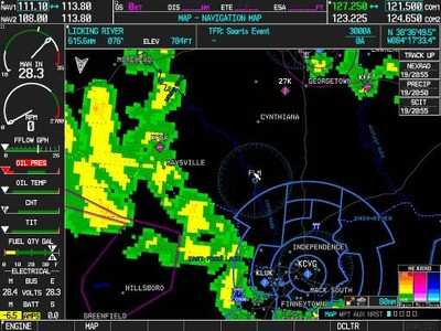
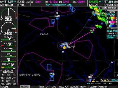
The GDL 69A is a new remote sensor that brings highly reliable,
near real-time weather information to the cockpit. The sensor
receives broadcast weather data from the XM WX Satellite Weather
service of XM Satellite Radio, and delivers the data to Garmin's
popular G1000 Integrated Avionics System installed in all NAV III
optioned aircraft. All weather services are continuously updated
and can be accessed on the G1000 display before take-off (for
example, high resolution Nexrad data is updated every 5 minutes).
Once XM WX data is received, Garmin's high-resolution displays show
the pilot valuable information in flight, coast-to-coast and
everywhere in between.
The XM WX Satellite Weather service is broadcast in the S-band
frequency over two powerful geosynchronous satellites for
rapid-update, high-resolution weather information directly into the
cockpit, at any altitude across the continental United States.
Since only the S-Band wavelength is able to easily penetrate dense
storm cells, the use of S-Band technology is a key factor and one
of the defining advantages of XM WX Satellite Weather.
The GDL 69A increases situational awareness by offering a broad
array of weather services and graphically depicts a high level of
detail on the displays:
- High-resolution NEXRAD weather data
- METARs (in graphical or textual format)
- TAFs
- TFRs
- Winds aloft (at altitude)
- Echo tops
- Precipitation type (at surface)
- Lightning
- Severe Weather Tracking (size, speed and direction)
- AIRMETs
- SIGMETs, and much more...
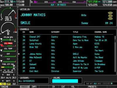
The GDL69A receiver also combines XM WX's weather services with
XM's digital audio entertainment, which provides 130-plus channels
of music, news, talk, sports and information.
The comprehensive weather data suite available through XM WX is
supplied by WxWorx, an innovator in location-specific weather data
and leading provider of analytical weather services to the
broadcast media and emergency management industry. XM WX Weather
products are available for the US continental 48 states.
More News
Aero Linx: Florida Antique Biplane Association "Biplanes.....outrageous fun since 1903." That quote really defines what the Florida Antique Biplane Association (FABA) is all about.>[...]
Beyond Visual Line Of Sight (BVLOS) The operation of a UAS beyond the visual capability of the flight crew members (i.e., remote pilot in command [RPIC], the person manipulating th>[...]
Also: ForeFlight Upgrades, Cicare USA, Vittorazi Engines, EarthX We have a number of late-breaking news highlights from the 2024 Innovation Preview... which was PACKED with real ne>[...]
“For Montaer Aircraft it is a very prudent move to incorporate such reliable institution as Ocala Aviation, with the background of decades in training experience and aviation>[...]
Maximum Authorized Altitude A published altitude representing the maximum usable altitude or flight level for an airspace structure or route segment. It is the highest altitude on >[...]
 ANN's Daily Aero-Linx (04.13.24)

