New Version Of ForeFlight Supports ADS-B Device For iPad | Aero-News Network
Aero-News Network
RSS icon RSS feed
podcast icon MP3 podcast
Subscribe Aero-News e-mail Newsletter Subscribe

Airborne Unlimited -- Most Recent Daily Episodes

Episode Date

Airborne-Monday

Airborne-Tuesday

Airborne-Wednesday Airborne-Thursday

Airborne-Friday

Airborne On YouTube

Airborne-Unlimited-04.01.24

Airborne-Unlimited-04.09.24

Airborne-Unlimited-04.10.24 Airborne-Unlimited-04.11.24

Airborne-Unlimited-04.12.24

Join Us At 0900ET, Friday, 4/10, for the LIVE Morning Brief.
Watch It LIVE at
www.airborne-live.net

Wed, Apr 18, 2012

New Version Of ForeFlight Supports ADS-B Device For iPad

In-Flight Weather Information From A Battery-Powered Receiver

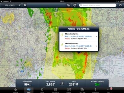
The new version of ForeFlight offers support for the Stratus portable ADS-B weather receiver introduced last month. On its blog, ForeFlight says that the new version 4.5 supports all FIS-B products transmitted by the ADS-B network. This includes high resolution regional NEXRAD, CONUS NEXRAD, METARs, TAFs, winds aloft, PIREPs, SUA information, TFRs, and NOTAMs.

Other enhancement included in the update are direct to route search syntax, estimated time of departure offsets for routes, naming favorite routes, map performance enhancements, and enhancements to the altitude rules in the File & Brief view. 4.5 also makes inputting a route direct from current location simple. As an example, to fly from your current position direct to KSFO airport, enter "D KSFO" in the route search box. The “D” in front of the identifier instructs the map to compute a course from your present location to the identifier, updating trip times, ETA, and fuel.

Favorite routes can also be named and saved under a "Favorite" menu. The name is optional, but when a name is provided, the named route appears in the favorite routes list.

The File & Brief view no longer enforces cardinal cruise altitude rules for flights under 4,100' MSL. This enhancement is to allow more flexibility for pilots flying down low or in the SFRA.

The new version if available now for download from the App store. Stratus begins shipping April 23.

In an advisory bulletin received by ANN Tuesday, ForeFlight tells users that after updating to the new version, plates, charts, and documents will have to be re-downloaded. To download data from iPad, tap on 'More' in the bottom-right, tap on 'Downloads', and then tap the green 'Download' button. To download data from iPhone, tap on the 'Download' icon and then tap the green 'Download' button.

ForeFlight Mobile also says that 4.5.1 - which is awaiting Apple's review - will land in the App Store in the next few days and will not require data re-downloading. Users who wait for 4.5.1 will not need to re-download data. The company says it will follow-up with an email as soon as 4.5.1 is available.

Before every flight, ForeFlight recommends a proper pre-flight of your iPad and apps to ensure data required for your flight is available.

FMI: www.foreflight.com

Advertisement

More News

ANN's Daily Aero-Linx (04.13.24)

Aero Linx: Florida Antique Biplane Association "Biplanes.....outrageous fun since 1903." That quote really defines what the Florida Antique Biplane Association (FABA) is all about.>[...]

ANN's Daily Aero-Term (04.13.24): Beyond Visual Line Of Sight (BVLOS)

Beyond Visual Line Of Sight (BVLOS) The operation of a UAS beyond the visual capability of the flight crew members (i.e., remote pilot in command [RPIC], the person manipulating th>[...]

Airborne 04.09.24: SnF24!, Piper-DeltaHawk!, Fisher Update, Junkers

Also: ForeFlight Upgrades, Cicare USA, Vittorazi Engines, EarthX We have a number of late-breaking news highlights from the 2024 Innovation Preview... which was PACKED with real ne>[...]

Aero-News: Quote of the Day (04.14.24)

“For Montaer Aircraft it is a very prudent move to incorporate such reliable institution as Ocala Aviation, with the background of decades in training experience and aviation>[...]

ANN's Daily Aero-Term (04.14.24): Maximum Authorized Altitude

Maximum Authorized Altitude A published altitude representing the maximum usable altitude or flight level for an airspace structure or route segment. It is the highest altitude on >[...]

blog comments powered by Disqus


Advertisement

Advertisement

Podcasts

Advertisement

© 2007 - 2024 Web Development & Design by Pauli Systems, LC