Many Of The Great Features Of The 496, But At Lower Prices
When it comes to offering big things in small packages, little
else compares to Garmin's know-it-all, do-it-all GPSMAP 496...
designed to offer (well, almost) everything a pilot could possibly
want and need in a portable GPS.
For some pilots, however, the 496 is TOO much of a good thing...
and has a pricetag to match. Recognizing a segment of the pilot
community who wants the functionality and reliability of the GPS
496 -- but not necessarily ALL the bells and whistles --
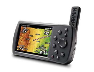
Garmin unveiled Wednesday its GPSMAP 495 portable aviation
device.
Garmin says the new GPS 495 is designed for pilots who want many
of the same features as the popular 496, at a fraction of the cost.
The GPSMAP 495 includes Garmin's SafeTaxi airport diagrams,
Garmin's Smart Airspace, AOPA's Airport Directory data, enhanced
high-resolution terrain database, aviation database with private
airports and heliports, accelerated GPS update rate, and European
VFR reporting waypoints.
"Those familiar with our aviation handheld product line will see
the GPSMAP 495 as a cross between the GPSMAP 296 and GPSMAP 496
because it provides some of the advanced features found on the
GPSMAP 496, but is closer to the GPSMAP 296's price point," said
Gary Kelley, Garmin's vice president of marketing.
 The GPSMAP 495 incorporates the
same, higher resolution terrain database found on the GPSMAP 496.
The land graphics have over 10 times as much data as other Garmin
handhelds and vividly display proximity hazards. In aviation mode,
pilots have the benefit of terrain and obstacle alerting, pop-up
alerts, and customizable minimum clearance limits that give audible
terrain alerts at specified altitudes.
The GPSMAP 495 incorporates the
same, higher resolution terrain database found on the GPSMAP 496.
The land graphics have over 10 times as much data as other Garmin
handhelds and vividly display proximity hazards. In aviation mode,
pilots have the benefit of terrain and obstacle alerting, pop-up
alerts, and customizable minimum clearance limits that give audible
terrain alerts at specified altitudes.
Pilots will also appreciate Garmin's Smart Airspace feature that
automatically highlights airspace close to the pilot's current
altitude and de-emphasizes airspace away from the current
altitude.
Like the GPSMAP 496, the GPSMAP 495 has an increased GPS update
rate that is five times faster than other handheld GPS devices.
This impressive speed gives fluid updates of GPS derived data
including the aircraft's flight indicators, such as the HSI and
turn rate indicator.
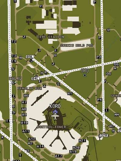
The GPSMAP 495's SafeTaxi diagrams and Aircraft Owners and
Pilots Association (AOPA) Airport Directory data help reduce the
headaches associated with navigating unfamiliar taxiways and
airports. With over 850 US airport diagrams preloaded, SafeTaxi
lets pilots see the aircraft's exact location on the field in
relation to charts that identify runways, taxiways and hangars. The
preloaded AOPA Airport Directory data includes information for over
5,300 public-use airports and more than 7,000 FBOs, such as pilot
services, ground transportation, lodging, restaurants, and local
attractions. In addition, Garmin's version of the AOPA's Airport
Directory highlights airports where pilots can save on fuel by
using self-service fueling locations.
The GPSMAP 495 does not include the GXM 30A smart antenna with
XM WX Satellite Weather, and it is not compatible with the GXM 30A
smart antenna.
Those who want to use the GPSMAP 495 on the road or water can do
so by adding optional MapSource City Navigator street maps or
BlueChart marine cartography. City Navigator helps drivers navigate
unfamiliar streets with turn-by-turn, voice-prompted directions to
specific addresses and points of interests.
When MapSource BlueChart marine cartography is installed, the
waterproof GPSMAP 495 displays information like depth contours,
inter-tidal zones, spot soundings, wrecks, navaids, port plans,
restricted areas, cable areas and anchorages.
The GPSMAP 495 is expected to be available April 8-13, 2008, at
the upcoming Lakeland Fly-In. The expected street price is
$1,595.00. Those who purchase a GPSMAP 495 at the fly-in are also
eligible to receive a $100 rebate.
The GPSMAP 495 package includes a yoke mount, cigarette-lighter
adapter, AC adapter cable, USB-to-PC interface cable, low-profile
remote GPS antenna, carrying case, free Jeppesen update
certificate, owner's manual and quick-reference guide.
 Aero-News: Quote of the Day (04.17.24)

