Spacecraft Will Lead To Improve Forecasts, NOAA Says
NASA has successfully launched for the National Oceanic and Atmospheric Administration (NOAA) the first in a series of four highly advanced polar-orbiting satellites, equipped with next-generation technology and designed to improve the accuracy of U.S. weather forecasts out to seven days.
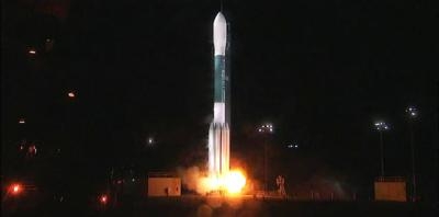
The Joint Polar Satellite System-1 (JPSS-1) lifted off on a United Launch Alliance Delta II rocket from Vandenberg Air Force Base, California, at 1:47 a.m. PST Saturday.
Approximately 63 minutes after launch the solar arrays on JPSS-1 deployed and the spacecraft was operating on its own power. JPSS-1 will be renamed NOAA-20 when it reaches its final orbit. Following a three-month checkout and validation of its five advanced instruments, the satellite will become operational.
"Launching JPSS-1 underscores NOAA's commitment to putting the best possible satellites into orbit, giving our forecasters -- and the public -- greater confidence in weather forecasts up to seven days in advance, including the potential for severe, or impactful weather," said Stephen Volz, director of NOAA's Satellite and Information Service.
JPSS-1 will join the joint NOAA/NASA Suomi National Polar-orbiting Partnership satellite in the same orbit and provide meteorologists with observations of atmospheric temperature and moisture, clouds, sea-surface temperature, ocean color, sea ice cover, volcanic ash, and fire detection. The data will improve weather forecasting, such as predicting a hurricane's track, and will help agencies involved with post-storm recovery by visualizing storm damage and the geographic extent of power outages.
"Emergency managers increasingly rely on our forecasts to make critical decisions and take appropriate action before a storm hits," said Louis W. Uccellini, director of NOAA's National Weather Service. "Polar satellite observations not only help us monitor and collect information about current weather systems, but they provide data to feed into our weather forecast models."
JPSS-1 has five instruments, each of which is significantly upgraded from the instruments on NOAA's previous polar-orbiting satellites. The more-detailed observations from JPSS will allow forecasters to make more accurate predictions. JPSS-1 data will also improve recognition of climate patterns that influence the weather, such as El Nino and La Nina.
The JPSS program is a partnership between NOAA and NASA through which they will oversee the development, launch, testing and operation all the satellites in the series. NOAA funds and manages the program, operations and data products. NASA develops and builds the instruments, spacecraft and ground system and launches the satellites for NOAA. JPSS-1 launch management was provided by NASA's Launch Services Program based at the agency's Kennedy Space Center in Florida.
"Today's launch is the latest example of the strong relationship between NASA and NOAA, contributing to the advancement of scientific discovery and the improvement of the U.S. weather forecasting capability by leveraging the unique vantage point of space to benefit and protect humankind," said Sandra Smalley, director of NASA's Joint Agency Satellite Division.
Ball Aerospace designed and built the JPSS-1 satellite bus and Ozone Mapping and Profiler Suite instrument, integrated all five of the spacecraft's instruments and performed satellite-level testing and launch support. Raytheon Corporation built the Visible Infrared Imaging Radiometer Suite and the Common Ground System. Harris Corporation built the Cross-track Infrared Sounder. Northrop Grumman Aerospace Systems built the Advanced Technology Microwave Sounder and the Clouds and the Earth's Radiant Energy System instrument.
(Source: NASA news release)
 ANN's Daily Aero-Linx (04.15.24)

