NASA Undertakes First Antarctic Airborne Campaign From McMurdo Station | Aero-News Network
Aero-News Network
RSS icon RSS feed
podcast icon MP3 podcast
Subscribe Aero-News e-mail Newsletter Subscribe

Airborne Unlimited -- Most Recent Daily Episodes

Episode Date

Airborne-Monday

Airborne-Tuesday

Airborne-Wednesday Airborne-Thursday

Airborne-Friday

Airborne On YouTube

Airborne-Unlimited-04.22.24

Airborne-Unlimited-04.16.24

Airborne-FlightTraining-04.17.24 Airborne-AffordableFlyers-04.18.24

Airborne-Unlimited-04.19.24

Join Us At 0900ET, Friday, 4/10, for the LIVE Morning Brief.
Watch It LIVE at
www.airborne-live.net

Sun, Nov 24, 2013

NASA Undertakes First Antarctic Airborne Campaign From McMurdo Station

Multi-Year Project to Study Antarctic Land And Sea Ice

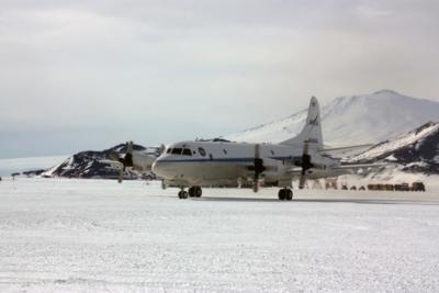
NASA's Operation IceBridge has begun its 2013 Antarctic field campaign with the arrival of the agency's aircraft and scientists at the National Science Foundation's McMurdo Station in Antarctica. The IceBridge mission will conduct daily survey flights through Nov. 26 on a NASA P-3 research aircraft from a base of operations at McMurdo Station. The P-3 usually is based at the agency's Wallops Flight Facility in Virginia. As part of a multi-year project, researchers are collecting data on Antarctic land and sea ice. Previous IceBridge Antarctic missions were conducted out of Punta Arenas, Chile.

"Flying from Antarctica will allow us to survey areas that had been unreachable from Chile," said Michael Studinger, IceBridge project scientist at NASA's Goddard Space Flight Center in Greenbelt, MD. "There are many scientifically important areas we can now reach from McMurdo."

One such area is the Siple Coast on the edge of Antarctica's Ross Ice Shelf. The ice streams there are of particular interest. "We know from spaceborne ice surface velocity measurements that some of the Siple Coast ice streams are changing," said Studinger. "But since 2009, we have had no laser altimeter measurements of ice surface elevations in this area."

In 2009, NASA's ice-monitoring satellite, the Ice, Cloud and Land Elevation Satellite (ICESat) reached the end of its life and stopped collecting data. IceBridge was started the same year and will keep an eye on changing polar ice until NASA launches the ICESat successor (ICESat-2) in three years.

IceBridge also plans to fly over areas of sea ice in and around the Ross Sea where there have been no airborne ice thickness measurements. The scientists will also survey beneath the Ross Ice Shelf using a gravimeter, an instrument that can detect minute changes in gravitational fields below the aircraft. These small changes help researchers determine the depth and shape of water cavities beneath floating ice.

The P-3 left Wallops Nov. 11 carrying a suite of instruments, including laser altimeters, radars, cameras and gravity and magnetic field sensors. The IceBridge team also has set up ground stations at McMurdo to collect global positioning system data.

Mission planners worked with the National Science Foundation and the U.S.  Antarctic Program for more than a year laying the groundwork for this campaign. The IceBridge project science office is located at Goddard.

(Image provided by NASA)

FMI: www.nasa.gov/icebridge

Advertisement

More News

ANN's Daily Aero-Term (04.20.24): Light Gun

Light Gun A handheld directional light signaling device which emits a brilliant narrow beam of white, green, or red light as selected by the tower controller. The color and type of>[...]

Aero-News: Quote of the Day (04.20.24)

"The journey to this achievement started nearly a decade ago when a freshly commissioned Gentry, driven by a fascination with new technologies and a desire to contribute significan>[...]

ANN's Daily Aero-Linx (04.21.24)

Aero Linx: JAARS, Inc. For decades now, we’ve landed planes on narrow rivers and towering mountains. We’ve outfitted boats and vehicles to reach villages that rarely se>[...]

Aero-News: Quote of the Day (04.21.24)

"Our driven and innovative team of military and civilian Airmen delivers combat power daily, ensuring our nation is ready today and tomorrow." Source: General Duke Richardson, AFMC>[...]

ANN's Daily Aero-Term (04.21.24): Aircraft Conflict

Aircraft Conflict Predicted conflict, within EDST of two aircraft, or between aircraft and airspace. A Red alert is used for conflicts when the predicted minimum separation is 5 na>[...]

blog comments powered by Disqus


Advertisement

Advertisement

Podcasts

Advertisement

© 2007 - 2024 Web Development & Design by Pauli Systems, LC