ADS-B Display Capability, Faster & Modernized Mapping Now Included
Garmin has rolled out enhanced capability and an expanded feature set for the G500/G600 glass flight display systems. Pilots will experience a faster, more responsive and modernized mapping display, complete with a number of enhancements that bring new capabilities to these flight displays.
In addition to a new, vibrant presentation, this update provides support for the display of advanced Automatic Dependent Surveillance-Broadcast (ADS-B) traffic and weather with the GDL 88, geo-referenced FliteCharts, a number of weather upgrades such as WX 500 Stormscope support, Canadian weather and more. Approval by the European Aviation Safety Agency (EASA) further extends the validation of this certification to also include hundreds of makes and models of European-registered general aviation aircraft.
“We continue to make significant enhancements to the G500 and G600 flight displays to ensure those who are considering an avionics upgrade, as well as our loyal Garmin customers who have invested in a Garmin glass cockpit, have access to the most forward-thinking capability available in the industry,” said Carl Wolf, vice president of aviation sales and marketing. “This update gives these displays a fresh, new look and expanded capabilities that reduce pilot workload and improve safety by putting valuable flight and navigation information in the pilot’s primary field of view. Backed by millions of flight hours, thousands of installations, hundreds of features, and an award-winning aviation product support team, the G500 and G600 flight displays give pilots a number of reasons to upgrade.”
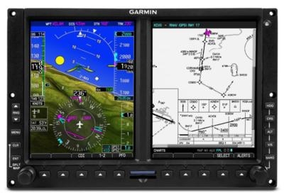
Newly improved dynamic maps expand upon the existing rich and vibrant mapping display capabilities within the G500/G600 glass flight display system. Expertise leveraged from incorporating dynamic maps within the GTN 650/750 touchscreen avionics series is integrated into the G500/G600, resulting in vivid and superior display quality. Pilots will notice the moving map offers faster display and map rendering and demonstrates an overall revitalized transformation of the existing avionics suite. In addition to the newly enhanced display capabilities, Geo-referenced Garmin FliteCharts terminal approach procedures add an elevated level of situational awareness. When flying an Instrument Approach Procedure (IAP), a magenta aircraft icon is overlaid on the approach plate so pilots can easily identify their location relative to the approach.
WireAware incorporates wire-strike avoidance technology to graphically overlay power line locations and altitude information on the moving map. Altitude is displayed in mean sea level (MSL) and above ground level (AGL), so power lines are easier to identify relative to the aircraft flight path. For added protection, Terrain Awareness and Warning System (TAWS) alerting is also available to provide visual and aural alerting. The new obstacle database contains Hazardous Obstacle Transmission (HOT) lines, which typically include those that span rivers, canyons, valleys or those that are within the vicinity of airports. Single updates for the new version of the obstacle database, including HOT lines, are available with U.S. coverage starting at $49.95. Annual subscriptions and PilotPaks are also available.
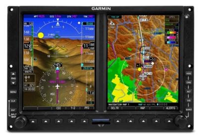
Smart Airspace integration makes it easier for pilots to identify what airspace lies ahead. This feature conveniently highlights the airspace nearest to the aircraft’s current altitude and de-emphasizes non-pertinent airspace so pilots can quickly distinguish their location to the relevant airspace around them. Additionally, newly incorporated airspace altitude overlays are depicted on the moving map and reduce pilot workload, particularly in congested airspace. With airspace altitude overlays, pilots can easily view airspace maximum and minimum altitudes within the U.S., so it’s easier to identify airspace altitude limitations at a glance.
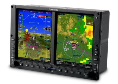
Garmin brings Vantage ADS-B integration to the G500/G600 with the optional GDL 88 ADS-B datalink, offering pilots the opportunity to display safety enhancing ADS-B traffic and subscription-free Flight Information Service-Broadcast (FIS-B) weather on these flight displays. TerminalTraffic provides pilots with a comprehensive picture of ADS-B-equipped aircraft and ground vehicles in the airport environment. ADS-B-equipped aircraft in-flight are easily distinguished from ground vehicles and taxiing aircraft, which are displayed using distinct colors and symbols. Enhancing the traffic display, TargetTrend relative motion technology helps pilots visualize the trend of traffic as it relates to their aircraft, while innovative dual-link technology provides pilots with the most comprehensive ADS-B traffic picture available in the industry. For customers with synthetic vision technology (SVT) enabled, traffic targets are also displayed on the PFD. Additionally, weather is easily accessible on the MFD of the
G500/G600, displaying weather products such as NEXRAD radar, METARs, TAFs, winds and temperatures aloft, AIRMETs, SIGMETs, PIREPs, as well as datalink TFRs, NOTAMs and SUA status information. By incorporating the GDL 88 ADS-B datalink, aircraft owners are provided a simple, rule-compliant ADS-B Out solution when operating in the U.S. below 18,000 feet, while receiving the safety benefits of ADS-B In traffic and weather.
New weather enhancements offer pilots access to optional weather products for display on the G500/G600 and provide expanded compatibility for additional weather radar systems. These new compatibilities include:
- GWX 70 adds optional ground clutter suppression and turbulence detection
- GWX 68/GWX 70 enhances existing support for multiple G500/G600 flight displays and GTN touchscreen avionics
- GDL 69 adds support for advanced weather products, such as icing, turbulence, PIREPs and Canadian weather
- WX-500 Stormscope support
Based on popular customer requests, the G500/G600 flight displays also offer additional functions and options, including:
- GRA 55/ GRA 5500 Radar Altimeter display support
- GMA 350 Marker Beacon display
- Selected altitude arc for easier visualization of desired altitude crossing point
- Pilot-selectable PFD clock/timer
- Altitude preselect for certain Cessna autopilots
- Support for full-screen display of external video on the MFD
- Pilot-selectable outside air temperature (OAT) measurement
In addition to FAA approval, Garmin has received EASA validation of the U.S. Supplemental Type Certificate (STC) for the latest G500/G600 software. With this STC, European customers can take advantage of broad level aircraft approval using an Approved Model List (AML) containing hundreds of aircraft makes and models. Customers who have previously incorporated the G500/G600 flight displays can take advantage of this approval by upgrading their systems to the latest software.
(Images provided by Garmin)
 ANN's Daily Aero-Linx (04.13.24)

