CAP Gives NWS Meteorologists Birds-Eye Views Of Ike Damage | Aero-News Network
Aero-News Network
RSS icon RSS feed
podcast icon MP3 podcast
Subscribe Aero-News e-mail Newsletter Subscribe

Airborne Unlimited -- Most Recent Daily Episodes

Episode Date

Airborne-Monday

Airborne-Tuesday

Airborne-Wednesday Airborne-Thursday

Airborne-Friday

Airborne On YouTube

Airborne-Unlimited-04.01.24

Airborne-Unlimited-04.16.24

Airborne-FlightTraining-04.17.24 Airborne-Unlimited-04.11.24

Airborne-Unlimited-04.12.24

Join Us At 0900ET, Friday, 4/10, for the LIVE Morning Brief.
Watch It LIVE at
www.airborne-live.net

Mon, Sep 22, 2008

CAP Gives NWS Meteorologists Birds-Eye Views Of Ike Damage

Ground Teams Pass Out Water, Food As Recon Flight Continue Overhead

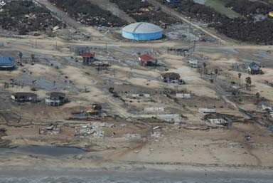
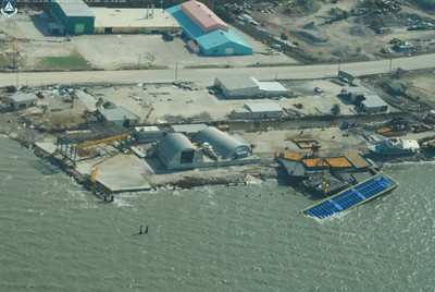
Civil Air Patrol pilots flew National Weather Service meteorologists up and down the East Texas coast Friday in a Gippsland GA8 Airvan. The meteorologists are developing a report on Hurricane Ike and they will use photography taken aloft in the CAP plane and observations made while flying along the coast and above Galveston in their assessment.

"This mission is going to help us with our ground data," said Patrick Blood, a NWS meteorologist. "Now we have aerial photos and video that we can tie together for our complete coastal report."

During the flight, Blood took about 800 photos that will help the NWS determine Ike’s wind speed, the amount of surge that overran Galveston Island and the distance storm debris traveled inland.

While the NWS was aloft with the Civil Air Patrol, other CAP volunteers served Houston residents on the ground at Manvel High School. Dozens of ground team members passed out bags of ice, bottled water and meals to residents driving through the school’s parking lot. CAP members also provided first aid to weary residents of Manvel, a community of about 7,000 just south of Houston.

Working beside CAP were Manvel residents, local volunteer emergency service providers and state police. Manvel Mayor Delores Martin also assisted the effort, and she appreciated CAP’s help, especially that provided by cadets.

"These young people have been tremendous," Martin said. "They didn't ask for anything but 'Give me a job.' They did everything, they picked up, they carried, they offered help to people."

According to Lt. Col. Brooks Cima, incident commander for Texas Wing's mission base at the West Houston Airport, more than 30 CAP members were staffing the distribution site.

More aircrews and ground team members, including some from CAP's Arkansas and Oklahoma wings, are expected to arrive at the Houston base this weekend to support ongoing aerial photography missions for the state of Texas. CAP aircrews' digital photos of critical infrastructure in the storm-ravaged areas are being used to restore essential services like power, water and fuel. Louisiana Wing is also flying similar missions for the state of Louisiana.

FMI: View Hurricane Damage Photos, www.cap.gov

Advertisement

More News

ANN's Daily Aero-Linx (04.15.24)

Aero Linx: International Flying Farmers IFF is a not-for-profit organization started in 1944 by farmers who were also private pilots. We have members all across the United States a>[...]

Classic Aero-TV: 'No Other Options' -- The Israeli Air Force's Danny Shapira

From 2017 (YouTube Version): Remembrances Of An Israeli Air Force Test Pilot Early in 2016, ANN contributor Maxine Scheer traveled to Israel, where she had the opportunity to sit d>[...]

Aero-News: Quote of the Day (04.15.24)

"We renegotiated what our debt restructuring is on a lot of our debts, mostly with the family. Those debts are going to be converted into equity..." Source: Excerpts from a short v>[...]

Airborne 04.16.24: RV Update, Affordable Flying Expo, Diamond Lil

Also: B-29 Superfortress Reunion, FAA Wants Controllers, Spirit Airlines Pulls Back, Gogo Galileo Van's Aircraft posted a short video recapping the goings-on around their reorganiz>[...]

ANN's Daily Aero-Term (04.16.24): Chart Supplement US

Chart Supplement US A flight information publication designed for use with appropriate IFR or VFR charts which contains data on all airports, seaplane bases, and heliports open to >[...]

blog comments powered by Disqus


Advertisement

Advertisement

Podcasts

Advertisement

© 2007 - 2024 Web Development & Design by Pauli Systems, LC