NASA P-3B To Fly Circular Descending Patterns To Sample Air Quality Over Various Locations
A multi-year NASA airborne science mission is on its way to California to help scientists better understand how to measure and forecast air quality globally from space. Two NASA aircraft equipped with scientific instruments will fly over the San Joaquin Valley between Bakersfield and Fresno in January and February to measure air pollution. One aircraft will fly within 1,000 feet of the ground.
The aircraft are part of NASA's five-year DISCOVER-AQ study, which stands for Deriving Information on Surface conditions from Column and Vertically Resolved Observations Relevant to Air Quality. Its researchers are working to improve the ability of satellites to consistently observe air quality in the lowest part of the atmosphere. If scientists could better observe pollution from space, they would be able to make better air quality forecasts and more accurately determine where pollution is coming from and why emissions vary.
A fundamental challenge for space-based instruments monitoring air quality is to distinguish between pollution high in the atmosphere and pollution near the surface where people live. DISCOVER-AQ will make measurements from aircraft in combination with ground-based monitoring sites to help scientists better understand how to observe ground-level pollution from space.
"DISCOVER-AQ is collecting data that will prepare us to make better observations from space, as well as determine the best mix of observations to have at the surface when we have new satellite instruments in orbit," said James Crawford, the mission's principal investigator at NASA's Langley Research Center in Hampton, Va. "NASA is planning to launch that satellite instrument, called TEMPO, in 2017."
Because many countries, including the United States, have large gaps in ground-based networks of air pollution monitors, experts look to satellites to provide a more complete geographic perspective on the distribution of pollutants. A fleet of Earth-observing satellites, called the Afternoon Constellation or "A-train," will pass over the DISCOVER-AQ study area daily in the early afternoon. The satellites' data, especially from NASA's Aqua and Aura spacecraft, will give scientists the opportunity to compare the view from space with that from the ground and aircraft. "The A-Train satellites have been useful in giving us a broader view of air pollution than we've ever had before," said Kenneth Pickering, DISCOVER-AQ's project scientist at NASA's Goddard Space Flight Center in Greenbelt, MD. "DISCOVER-AQ will help scientists interpret that data to improve air-quality analysis and regional air quality models."
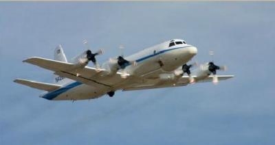
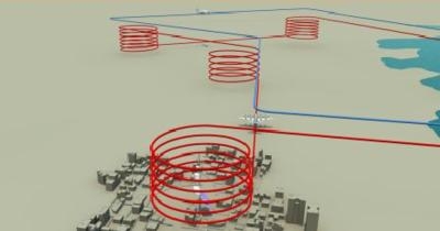
Test flights are scheduled to start January 16 with science flights continuing through mid-February. A four-engine P-3B turboprop plane from NASA's Wallops Flight Facility in Wallops Island, VA, will carry eight instruments. A two-engine B200 King Air aircraft from Langley will carry two instruments. Sampling will focus on agricultural and vehicle traffic areas extending from Bakersfield to Fresno. The flight path passes over six ground measurement sites operated by the California Air Resources Board and the San Joaquin Valley Air Pollution Control District.
The 117-foot-long P-3B will fly spiral flights over the ground stations. These flights will be from an altitude of 15,000 feet to as low as 1,000 feet. They will sample air along agricultural and traffic corridors at low altitudes between the ground stations. The smaller B200 King Air will collect data from as high as 26,000 feet. The plane's instruments will look down at the surface, much like a satellite, and measure particulate and gaseous air pollution. The two airplanes will fly from NASA's Dryden Aircraft Operations Facility in Palmdale, CA.
(Images courtesy NASA)
 ANN's Daily Aero-Linx (04.16.24)

