Voyager FPS and ANN Bring YOU The Weather In Oshkosh For Wednesday 07.19.06 | Aero-News Network
Aero-News Network
RSS icon RSS feed
podcast icon MP3 podcast
Subscribe Aero-News e-mail Newsletter Subscribe

Airborne Unlimited -- Most Recent Daily Episodes

Episode Date

Airborne-Monday

Airborne-Tuesday

Airborne-Wednesday Airborne-Thursday

Airborne-Friday

Airborne On YouTube

Airborne-Unlimited-04.01.24

Airborne-Unlimited-04.09.24

Airborne-Unlimited-04.10.24 Airborne-Unlimited-04.11.24

Airborne-Unlimited-04.12.24

Join Us At 0900ET, Friday, 4/10, for the LIVE Morning Brief.
Watch It LIVE at
www.airborne-live.net

Wed, Jul 19, 2006

Voyager FPS and ANN Bring YOU The Weather In Oshkosh For Wednesday 07.19.06

As Provided By Seattle Avionics And ANN!

We're gonna help you to get to the fabled land of Oshkosh... with a little help from our friends!

In conjunction with our friends at Seattle Avionics, Aero-News will be offering a Travel Update on our homepage, as well as for readers of our daily Propwash newsletter, throughout AirVenture 2006.

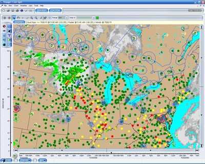
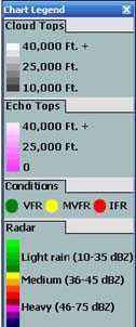
The graphic image, updated every morning, will show TFRs, radar, cloud cover, winds aloft, and other data... all appearing on a chart similar to what you'll find in Seattle Avionics' Voyager FreeFlight software.

What's more, you can customize this image to display whatever YOU want to show!

Traveling To Oshkosh?

This morning's weather report and airspace update are shown updated at 7:00 AM EDT 07.19.06.


DUAT WEATHER

SYNOPSIS...10Z SURFACE LOW CENTRAL SD. COLD FRONT FROM NORTHWESTERN MN THROUGH SD LOW TO E CENTRAL WY. WRMFRONT FROM SD LOW ACROSS NORTHEASTERN NEB/E CENTRAL MO BECMG STATIONARY ACROSS NORTHERN KY. HIGH PRESSURE OVER LH WITH RDG THROUGH NORTHERN IL. INCREASING SOUTHERLY LOW LEVEL WINDS OVER EASTERN NEB AND KS. STRONG POSS SEVERE THUNDERSTORMS FORECAST OVER UPPER MS VALLEY AND GREAT LAKES REGION. 04Z WEAK LOW SOUTHWESTERN IA WITH COLD FRONT ACROSS NORTHWESTERN KS. WRMFRONT FROM IA LOW THROUGH NORTHEASTERN KY.


WI SOUTHWESTERN HALF...SCATTERED CIRRUS. 14Z SCATTERED 3/8-4/8 COVERAGE AT 15000 FT. 19Z ABOVE GROUND LEVEL SCATTERED 3/8-4/8 COVERAGE AT 6000 FT SCATTERED 3/ 8-4/8 COVERAGE-BROKEN 5/8-7/8 COVERAGE AT 12000 FT TOP FL250. ISOL LIGHT THUNDERSTORM RAIN. CUMULONIMBUS TOP FL400. OUTLOOK...VFR. BECMG 0002 VFR THUNDERSTORM RAIN. NORTHEASTERN HALF...SCATTERED CIRRUS. OUTLOOK...VFR. BECMG 0305 VFR THUNDERSTORM RAIN.

Pretty cool, eh? But wait... it gets even better. In addition to displaying this information on the Aero-News website... Seattle Avionics is also offering a special, FREE version of Voyager FreeFlight for ANN readers to download for their personal use.

For an up-to-the-minute look at the weather, airspace, and airport data for your flight, be sure to download your 100% FREE version of Voyager FreeFlight Flight Planner, courtesy of Aero-News. Use it for your flight to Oshkosh... and for your flights to come!

FMI: Download Your ANN FreeFlight Flight Planner Here

Advertisement

More News

ANN's Daily Aero-Linx (04.13.24)

Aero Linx: Florida Antique Biplane Association "Biplanes.....outrageous fun since 1903." That quote really defines what the Florida Antique Biplane Association (FABA) is all about.>[...]

ANN's Daily Aero-Term (04.13.24): Beyond Visual Line Of Sight (BVLOS)

Beyond Visual Line Of Sight (BVLOS) The operation of a UAS beyond the visual capability of the flight crew members (i.e., remote pilot in command [RPIC], the person manipulating th>[...]

Airborne 04.09.24: SnF24!, Piper-DeltaHawk!, Fisher Update, Junkers

Also: ForeFlight Upgrades, Cicare USA, Vittorazi Engines, EarthX We have a number of late-breaking news highlights from the 2024 Innovation Preview... which was PACKED with real ne>[...]

Aero-News: Quote of the Day (04.14.24)

“For Montaer Aircraft it is a very prudent move to incorporate such reliable institution as Ocala Aviation, with the background of decades in training experience and aviation>[...]

ANN's Daily Aero-Term (04.14.24): Maximum Authorized Altitude

Maximum Authorized Altitude A published altitude representing the maximum usable altitude or flight level for an airspace structure or route segment. It is the highest altitude on >[...]

blog comments powered by Disqus


Advertisement

Advertisement

Podcasts

Advertisement

© 2007 - 2024 Web Development & Design by Pauli Systems, LC