Jeppesen Standardizes Runway Incursion 'Hot Spot' Depictions | Aero-News Network
Aero-News Network
RSS icon RSS feed
podcast icon MP3 podcast
Subscribe Aero-News e-mail Newsletter Subscribe

Airborne Unlimited -- Most Recent Daily Episodes

Episode Date

Airborne-Monday

Airborne-Tuesday

Airborne-Wednesday Airborne-Thursday

Airborne-Friday

Airborne On YouTube

Airborne-Unlimited-05.20.24

Airborne-Unlimited-05.28.24

Airborne-FlightTraining-05.29.24 Airborne-Unlimited-05.30.24

Airborne-Unlimited-05.24.24

Thu, May 17, 2007

Jeppesen Standardizes Runway Incursion 'Hot Spot' Depictions

Magenta Means "Be Extra Cautious"

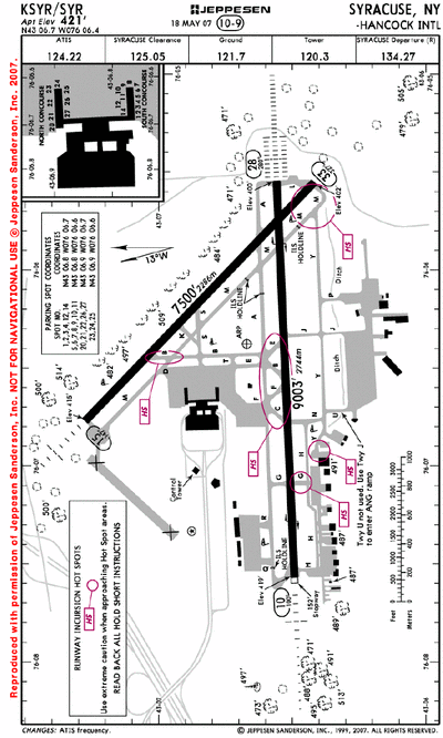
In an effort to help bring additional awareness to the ongoing issue of runway incursions, Jeppesen tells ANN the company recently began the process of depicting runway incursion hot spots in a standardized magenta color on certain airport diagrams in the worldwide library.

Hot spots on paper charts will be converted from gray to the magenta depiction as they are revised, thus making them easier for pilots to identify. Jeppesen electronic charts have displayed hot spots in red for some time, but in the summer 2007 these too will be switched to the now Jeppesen standard magenta color. The affected electronic charts will be switched all at once.

Airport hot spots are designated at airports by aeronautical authorities around the world and are intended to heighten awareness of areas on an airport surface that could cause positional awareness confusion for pilots. Jeppesen depicts hot spots with the designator “HS1, HS2, HS3...” and a magenta circle around the region. Often hot spots exist at airports with many intersecting taxiways and runways, and/or complex ramp areas. 

“Runway incursions continue to be a safety concern for the aviation industry,” said Mark Van Tine, Jeppesen president and COO. “By standardizing the way runway incursion hot spots are depicted on our charts we aim to increase awareness among pilots by making the hot spots a prominent, easily identifiable chart feature. Jeppesen is also taking proactive steps to improve positional awareness on the ground through our digital Airport Moving Map application that provides pilots a very detailed rendering of airport surface features along with an aircraft position spotter.”

Jeppesen is a subsidiary of Boeing Commercial Aviation Services, a unit of Boeing Commercial Airplanes.

FMI: www.jeppesen.com

Advertisement

More News

ANN FAQ: Contributing To Aero-TV

How To Get A Story On Aero-TV News/Feature Programming How do I submit a story idea or lead to Aero-TV? If you would like to submit a story idea or lead, please contact Jim Campbel>[...]

ANN's Daily Aero-Linx (05.29.24)

Aero Linx: International Association of Professional Gyroplane Training (IAPGT) We are an Association of people who fly, build or regulate Gyroplanes, who have a dream of a single >[...]

ANN's Daily Aero-Term (05.29.24): NORDO (No Radio)

NORDO (No Radio) Aircraft that cannot or do not communicate by radio when radio communication is required are referred to as “NORDO.”>[...]

Airborne 05.28.24: Jump Plane Down, Starship's 4th, Vision Jet Problems

Also: uAvionix AV-Link, F-16 Viper Demo, TN National Guard, 'Staff the Towers' A Saturday afternoon jump run, originating from SkyDive Kansas City, went bad when it was reported th>[...]

ANN's Daily Aero-Term (05.30.24): Beyond Visual Line Of Sight (BVLOS)

Beyond Visual Line Of Sight (BVLOS) The operation of a UAS beyond the visual capability of the flight crew members (i.e., remote pilot in command [RPIC], the person manipulating th>[...]

blog comments powered by Disqus


Advertisement

Advertisement

Podcasts

Advertisement

© 2007 - 2024 Web Development & Design by Pauli Systems, LC